

Take a breath before you start. I want you to picture something completely ordinary. Early this morning somebody in a village in Maharashtra pulled onions out of the ground and stacked them into a truck. The truck found a district road, the district road fed into a national highway, the highway ended at a railway goods yard, and a clerk somewhere tapped out a message saying the load was on its way. Two days later a woman in Guwahati bought those onions for her kitchen. Not one person in that chain ever met another person in it. And yet it worked, quietly, the way it works every single day. That invisible chain is the entire subject of this chapter. Once you can see it, the chapter stops being a list to memorise and becomes something you already understand.
The formal name for this chain is transport and communication, and the textbook calls these things the lifelines of the national economy. That word lifeline is doing real work. A lifeline is not the body itself; it is what keeps the body alive. Farms, factories, mines and markets are the organs of the economy. Roads, railways, pipelines, waterways, airways, post offices, phones and television are the arteries and nerves that keep those organs connected. Cut the arteries and the organs die, no matter how healthy they looked a minute earlier. That is the one sentence the whole chapter hangs from, and I will keep coming back to it.
Now I have to tell you something unusual about this particular chapter before we go one step further, because it changes how you should spend your time. Please read the amber box below carefully. It is not a warning, it is a plan.
In the official CBSE Class X Social Science curriculum 2026-27, this chapter carries an explicit note beside its name: only map pointing is to be evaluated in the Board Examination. In plain words, the theory of Lifelines of National Economy is taught, is examinable in your school unit tests and periodic assessments, and is fully part of your syllabus, but in the Board paper itself the marks from this chapter come through the map question. So do not skip the chapter, and do not treat the theory as optional either. Just be clear-eyed about where the Board marks sit: they sit on the map. That is why the map drill on this page is the longest and most heavily worked section of everything below.
I want to be straight with you about why skipping would still be a mistake, because a lot of students hear map-only and immediately close the book. Three reasons. First, your school marks are not the Board paper; unit tests, half-yearly papers and internal assessment can and do ask the theory. Second, this chapter is the bridge into Economics, where sectors of the economy, globalisation and trade all assume you already understand ports, exports and balance of trade; students who skipped this chapter reliably struggle there. Third, if you continue with Geography or Economics after Class 10, this is the foundation everything sits on. So we will learn it properly. We will simply be honest about weighting, and give the map the biggest share of our effort.
- Your Game Plan
- Why Transport And Communication Are Called Lifelines
- Roadways In India And The Six Classes Of Roads
- Road Density And Why It Is So Uneven
- Railways: Their Role And The Problems They Face
- How Relief And Economy Shape The Railway Network
- Pipelines: The Quiet Transport System
- Waterways And The National Waterways
- Major Sea Ports Of India
- Airways: Domestic, International, Advantages And Limits
- Communication: Personal And Mass
- Print And Electronic Media In India
- International Trade: Exports, Imports And Balance Of Trade
- Why Trade Is Called The Economic Barometer
- Tourism As A Trade And An Employment Generator
- Comparing All Five Modes Of Transport
- Map Skill Drill: The Official Locate And Label List
- The Three Confusion Pairs That Cost Marks
- Practice Worksheet With Answers
- Kaizen: One Better Than Yesterday
Your Game Plan
Because the Board scope for this chapter is the map, the order in which you study matters more than usual. Most students work front to back and run out of energy exactly when they reach the map at the end. We are going to invert that. Here is the sequence I would use if I were sitting next to you.
- Start with the map, not the theory. Jump straight to the map drill section, print or draw a blank outline map of India, and learn the ten sea ports and six international airports until you can place them without thinking. This is where your Board marks live. Give it your freshest attention, not your leftover attention.
- Learn the coastline as a loop, not a list. You will see in the drill that the ports fall into a beautifully tidy pattern going down the west coast and back up the east coast. Learn the pattern and the list comes free.
- Then read the theory in order, one section a sitting. Roads, railways, pipelines, waterways, ports, airways, communication, trade, tourism. Do not try to do all of it in one evening. Nine short sittings beat one long miserable one.
- Attempt the worked examples yourself before reading the answer. Cover the model answer with your hand. Write your own. Then compare. The gap between your answer and mine is your actual syllabus.
- Do the four tables as active recall. Cover a column, say it out loud, uncover, check. The port table and the airport table are the two highest-value assets on this page.
- Finish with the practice worksheet, and then go back to the map one final time. Map first, map last. That is the whole strategy.
Knowing what to study is a smaller skill than knowing how much to study each thing. A chapter whose Board marks come from the map deserves map-heavy revision, and a chapter that feeds Economics deserves an honest read-through of the theory. Both things are true at once. Students lose marks far more often from bad weighting than from bad memory.
Why Transport And Communication Are Called Lifelines
Let us build this idea from absolutely nothing, because if you get this right, half the chapter answers itself.
Imagine a village that is completely cut off. No road, no railway line, no phone signal, no post. The people there can still farm. They can still weave cloth. They can still make pots. So they are not helpless. But notice what they cannot do. They cannot sell a surplus, because there is no market within reach. They cannot buy anything they do not make themselves, so no medicines, no fertiliser, no machinery. They cannot find out what a fair price is, because no information reaches them. And if the harvest fails, no relief can arrive. That village has production but no economy. It has activity but no exchange.
Now lay one all-weather road into that village and watch what changes. The surplus onions become income. The income buys a pump. The pump raises the yield. A trader arrives, and now there are two buyers instead of one, so the price improves. A child can reach a secondary school in the next town. A phone tower goes up and suddenly the farmer knows the mandi rate before he loads the truck, so he stops being cheated. Nothing about the soil changed. Nothing about the seeds changed. The connection changed, and the connection was worth more than either.
That is why we call these things lifelines. Transport moves goods and people. Communication moves information and ideas. Together they turn scattered pockets of production into one working national economy. Three specific jobs are worth naming, because examiners like them named.
- They link production to consumption. Raw materials reach factories, finished goods reach markets, and food reaches people who did not grow it. Without this link, specialisation is pointless, because nobody can trade what they specialise in.
- They allow specialisation and regional division of labour. Assam can concentrate on tea and Punjab on wheat only because both can be moved. A region that must produce everything for itself can never be good at anything.
- They bind the country together socially and politically. Trade, migration, tourism, news and pilgrimage all travel on these networks. National integration is not only an emotion; it has a physical infrastructure underneath it.
One more idea that students often miss. Transport and communication are described as tertiary activities, that is, services. They do not grow anything or manufacture anything. They add value by moving things and by moving information. That is why they belong to the service sector, and that is one of the direct bridges from this chapter into your Economics chapters.
Transport and communication are called lifelines because the economy cannot function without them, just as a body cannot function without arteries and nerves. [framing sentence, earns nothing on its own but sets up the points]
(i) They link areas of production with areas of consumption, so raw materials reach industries and finished goods reach markets. [1]
(ii) They make regional specialisation possible, because a region can concentrate on what it produces best only if that produce can be carried elsewhere and its other needs brought in. [1]
(iii) They promote national integration and help in the movement of people, relief material and information across the country. [1]
Why it works: a 3-mark answer wants three distinct, separable points, not one point said three times. Notice each numbered line could stand alone. That separability is what the examiner is scanning for.
(i) Farmers can now carry surplus produce to a town market instead of selling only within the village, so agriculture shifts from subsistence towards commercial production and household incomes rise. [1]
(ii) Inputs and services that could not reach the village earlier, such as fertilisers, improved seeds, medicines and machinery, become available, which raises productivity. [1]
(iii) New employment appears in transport, trade and repair work, and access to schools, hospitals and government offices in nearby towns improves, which reduces the pressure to migrate permanently. [1]
Why it works: the question says economic changes, so every point is tied to income, production, employment or access. If you had written that the village looks nicer, you would earn nothing. Match your content word to the command word.
They are partners, not twins. Transport moves physical things: goods and people. Communication moves non-physical things: messages, information, ideas. A letter is interesting precisely because it sits between the two, since the paper must be carried but the value is in the information. If a question asks about communication, do not fill your answer with highways.
Roadways In India And The Six Classes Of Roads
India has one of the largest road networks in the world. But before the classification, let us understand why roads have quietly overtaken railways in importance, because that reasoning is worth marks and most students cannot produce it.
Think about the difference between a railway and a road. A railway needs a fixed track, and that track has to be laid, levelled, bridged and maintained. It is expensive per kilometre and it can only go where the engineers have already put steel. A road is far cheaper to build, it can climb gradients a train cannot manage, it can be pushed into dissected and hilly terrain where laying track would be absurd, and it can be built across a much wider range of landscapes. And then there is the point that decides everything.
A train can never take a sack of grain from a farmer’s field, and it can never deliver it to a shop door. Something has to carry the goods from the field to the station and from the station to the shop. That something is a road. So road transport provides door-to-door service, the cost of loading and unloading is much lower, and roads act as a feeder to all other modes: they link railway stations, air ports and sea ports to the places goods actually come from. Even when a railway carries the long middle stretch, roads carry both ends. Write this in any comparison answer and it will earn its mark.
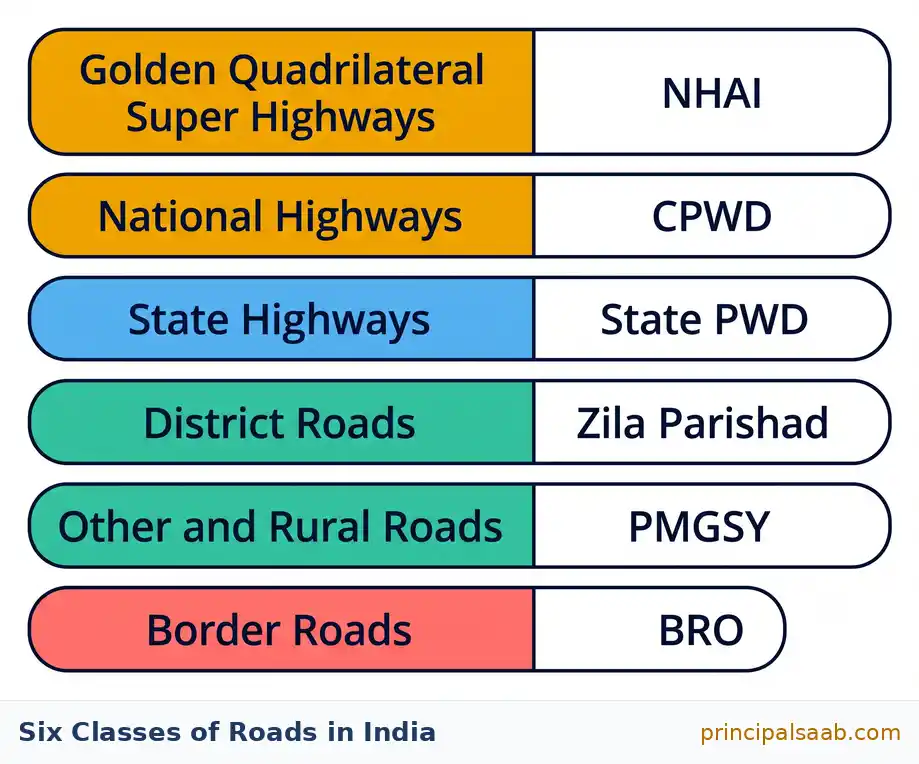
Roads also carry perishable goods more efficiently over short distances, because they avoid the waiting, transshipment and handling that rail freight involves. And the construction cost of a road is roughly a fraction of that of a railway line of the same length, which matters enormously in a developing economy. Now, the classification. In India roads are grouped into six classes according to their capacity and who is responsible for them. Learn the list in this order, because it runs from the biggest to the smallest and then adds the special case at the end.
1. Golden Quadrilateral Super Highways
This is the flagship project of major highway building, executed through the National Highways Authority of India, the NHAI. It has three named parts and you must be able to name the end points of each.
- The Golden Quadrilateral links the four big metropolitan cities: Delhi, Kolkata, Chennai and Mumbai, and back to Delhi. Four cities, four sides, a quadrilateral. It is roughly 5,800 kilometres of six-lane super highway.
- The North-South Corridor runs from Srinagar in the far north to Kanniyakumari at the southern tip, including a spur to Kochi. Top of the country to the bottom.
- The East-West Corridor runs from Silchar in Assam in the east to Porbandar in Gujarat in the west.
The purpose is simple and you should say it in these terms: to reduce the time and distance between the mega cities of India, which cuts transport cost, speeds up the movement of freight, and links major industrial, agricultural and commercial centres. If you can remember only two things here, remember Srinagar to Kanniyakumari and Silchar to Porbandar. Those four place names appear in questions far more often than the corridor lengths do.
North-South: Srinagar to Kanniyakumari, and helpfully the sound of the word Kanniyakumari already tells you it is the southern tip. East-West: Silchar to Porbandar, and both are slightly obscure towns rather than famous cities, which is exactly why examiners like them. Say the four names aloud five times now. It takes twenty seconds and it is worth a mark.
2. National Highways
National Highways link the extreme parts of the country. They are the primary road system, laid and maintained by the Central Public Works Department, the CPWD. The historical example everybody quotes is the old highway from Delhi to Amritsar, which follows part of the alignment of the ancient Sher Shah Suri Marg, the road built in the sixteenth century between the Indus valley and the Sonar valley in Bengal. That is a nice detail because it shows how old the idea of a national trunk road is in India.
India renumbered its National Highways in 2010, so the number your textbook prints and the number on a signboard today may not match. Older books call the Varanasi to Kanniyakumari route the longest National Highway under its old number. If a question asks for it, answer with the numbering your prescribed textbook uses and, if you want to be safe, name the end points as well, since the end points have not changed even though the numbers did. Never invent a highway number you are not sure of.
3. State Highways
State Highways link a state capital with the district headquarters of that state. They are constructed and maintained by the State Public Works Department, the State PWD. The clean way to hold this in your head is a chain of command: national highways join states to states, state highways join the state capital to its districts.
4. District Roads
District roads connect the district headquarters with the other places of the district. They are maintained by the Zila Parishad. Notice the pattern continuing downwards: centre, state, district. Each level of government maintains the roads of its own level. That is the single easiest way to remember who maintains what.
5. Other Roads, Including Rural Roads And PMGSY
These are the rural roads that link villages to towns and to each other. They received a major push under the Pradhan Mantri Grameen Sadak Yojana (PMGSY), launched around the year 2000, whose aim is to provide all-weather road connectivity to unconnected villages. That phrase all-weather is the important one and you should use it rather than just saying road. A kutcha track that dissolves in the monsoon connects a village for eight months and abandons it for four, which is exactly when farmers most need to move produce and reach a hospital.
6. Border Roads
The Border Roads Organisation (BRO), established in 1960, is a Government of India undertaking that constructs and maintains roads in the bordering areas of the country, especially along the northern and north-eastern boundaries. Two functions, and give both if asked. It has strategic importance, because it allows the movement of defence personnel and equipment to sensitive border areas. And it has economic and social importance, because it has improved accessibility in areas of difficult terrain, opening up remote high-altitude and hill regions to trade, supplies, health care and the wider economy. The BRO also undertakes snow clearance in high-altitude passes.
One extra classification you should know, because it is easy marks. Roads are also classified by the material used to build them. Metalled roads are surfaced with cement, concrete or bitumen and are usable in all seasons; these are the pucca roads. Unmetalled roads are made of packed earth or gravel and go out of use in the rainy season; these are the kutcha roads. That single fact, that unmetalled roads fail in the monsoon, is the reason PMGSY exists.
| Class of road | What it connects | Built or maintained by | Remember it by |
|---|---|---|---|
| Golden Quadrilateral Super Highways | Delhi, Kolkata, Chennai and Mumbai; plus the North-South corridor (Srinagar to Kanniyakumari) and the East-West corridor (Silchar to Porbandar) | National Highways Authority of India (NHAI) | Four metros, four sides, plus one vertical and one horizontal line across the map |
| National Highways | Extreme parts of the country; state to state; the primary trunk network | Central Public Works Department (CPWD) | National level, so Central department. Historic example: the Sher Shah Suri Marg alignment |
| State Highways | State capital to the district headquarters of that state | State Public Works Department (State PWD) | State level, so State department |
| District Roads | District headquarters to other places within the same district | Zila Parishad | District level, so the district council |
| Other Roads (rural roads) | Villages to towns and to each other; the last mile of the network | Given a major push by the Pradhan Mantri Grameen Sadak Yojana (PMGSY), launched around 2000 | Key phrase: all-weather connectivity to unconnected villages |
| Border Roads | Roads in the bordering areas, especially the northern and north-eastern boundaries | Border Roads Organisation (BRO), set up in 1960 | Two purposes: strategic (defence) and economic (accessibility in difficult terrain) |
(i) The construction cost of roads is much lower than that of railway lines, so a road network can be extended far more widely for the same money. [1]
(ii) Roads can be built in dissected, hilly and undulating terrain and can negotiate steeper gradients, so they reach places where laying a railway track is difficult or impossible. [1]
(iii) Road transport provides door-to-door service, so the cost of loading and unloading is much lower, and it acts as a feeder that links railway stations, air ports and sea ports to the actual points of production and consumption. [1]
Why it works: each reason is a different kind of reason, one about cost, one about terrain, one about function. Three reasons of the same kind read as one reason repeated. Vary the category and the examiner sees three.
The Border Roads Organisation, set up in 1960, is a Government of India undertaking that constructs and maintains roads in the bordering areas of the country, particularly along the northern and north-eastern boundaries. [1]
It has strategic importance, since these roads allow the rapid movement of defence personnel, equipment and supplies to sensitive border regions. [1]
It also has economic and social importance, since it has improved accessibility in areas of difficult mountainous terrain, opening remote high-altitude regions to trade, essential supplies, health care and administration, and it carries out snow clearance in high passes. [1]
Why it works: the question has two command words, describe and explain. The first line describes, the next two explain. If you only describe, you cap yourself at one mark however long you write.
Road Density And Why It Is So Uneven
This is a small section but it contains one definition that must be word-perfect, so let us slow down.
Road density is the length of road per 100 square kilometres of area. Not per person. Not per district. Per 100 square kilometres of area. Students lose this one mark constantly by writing per square kilometre or per lakh people. Say it out loud once: length of road, per hundred square kilometres of area.
Now, why does it vary so wildly across India? Because road density is really a measure of how easy the land is to build on and how much demand there is for movement. Put those two together and the pattern makes sense immediately.
- Density is high in the northern plains and in states with level or gently sloping terrain, dense population, intensive agriculture and industry. Flat land is cheap to build on and lots of people and goods need to move. Kerala is the classic example of very high road density.
- Density is low in mountainous, forested, desert and sparsely populated areas. Building is expensive and difficult, and fewer people and goods need moving, so there is less justification for the expense. The Himalayan states are the classic example of very low density, with Jammu and Kashmir quoted at the bottom of the range in the textbook data.
On actual numbers I want you to be careful, because they are dated and they get revised. The figures printed in the standard textbook come from around 2011 and put the national average at roughly 140 to 145 kilometres per 100 square kilometres, with Kerala above 500 and Jammu and Kashmir close to 12. Quote those as approximate textbook figures rather than as today’s truth, and if you are unsure of a number, describe the pattern instead. An examiner never penalises high density in Kerala and low density in the Himalayan states. An examiner does penalise a confidently wrong number.
There is one more honest problem with Indian roads worth a sentence in a long answer: about half the network is unsurfaced, the roads are inadequate for the traffic they now carry, national highways are a small share of total length but carry a hugely disproportionate share of traffic, and many highways lack the lanes and bridges the volume demands. Growth in vehicles has run ahead of growth in road capacity. That is why congestion, not distance, is often the real cost.
Road density means the length of road per 100 square kilometres of area. [1]
Kerala has a high road density because it has relatively level and easily accessible terrain, a very dense population, intensive commercial agriculture and many closely spaced settlements, all of which create heavy demand for movement and make road construction comparatively easy and worthwhile. [1]
Jammu and Kashmir has a low road density because much of it is high mountainous terrain where construction is extremely difficult and costly, the population is sparse and scattered, and heavy snowfall and rugged relief make road building and maintenance far harder. [1]
Why it works: the answer explains both ends of the comparison. A very common error is to explain only why Kerala is high and leave Jammu and Kashmir unexplained, which loses the third mark. Whenever a question compares two things, write about both.
Railways: Their Role And The Problems They Face
Railways are the principal mode of transport for freight and passengers in India, and they are much more than a way of getting about. I want you to hold two separate ideas here: what railways do for the economy, and what railways do for the country as a society. Examiners ask both.
Railways in India came in 1853, when the first train ran between Bombay and Thane over a stretch of about 34 kilometres. From that single line grew one of the largest railway networks in the world, running today to roughly 68,000 route kilometres and carrying a very large volume of passengers and goods every day. I will keep those figures deliberately approximate; route length and traffic figures change year to year, and it is better to write about 68,000 route kilometres in recent years than to state a precise number that may be out of date.
The network is administered in a number of zones. Your textbook may print sixteen; the number has been revised since, so if a question asks, quote the figure in your prescribed edition and do not argue with it. This is one of those places where the honest answer is to follow the book you are examined on.
What Railways Do
- They carry heavy and bulky goods over long distances cheaply. Coal, iron ore, foodgrains, cement and fertiliser move most economically by rail. A single freight train replaces a very large number of trucks.
- They make multipurpose activities possible. Railways make it possible to conduct business, sightseeing, pilgrimage and long-distance travel by ordinary people at a price they can afford.
- They bind the country together. Railways have played a major role in national integration by linking distant regions, allowing people to migrate for work, and letting cultures meet. They accelerated the growth of industry and agriculture wherever they reached.
- They are fuel-efficient for freight. Per tonne carried per kilometre, rail is far less fuel-hungry than road, which matters for both cost and the environment.
If a question asks why coal or iron ore travels by rail rather than road, the winning word is bulky, paired with long distance and low cost per tonne. If a question asks why vegetables or milk travels by road, the winning words are perishable, short distance and door-to-door. Two small vocabularies, two very different questions. Keep them apart.
The Problems Railways Face
This is a favourite question and the answers are pleasingly concrete. Notice that most of them are about public behaviour rather than about engineering, which is an interesting point to make in a long answer.
- Ticketless travel. Large numbers of people travel without tickets, which drains revenue that would otherwise pay for better tracks, coaches and safety systems.
- Theft and damage of railway property. Fittings, taps, bulbs, cushions, cables and even track material are stolen or vandalised, and every rupee of replacement is a rupee not spent on improvement.
- Unnecessary chain pulling. Pulling the alarm chain without a real emergency stops the train, delays it and disrupts the timetable behind it, since every train on that line is affected.
- Crossing tracks and unmanned level crossings. People cross tracks instead of using bridges and subways, and unmanned crossings cause serious accidents. This is a safety problem before it is an economic one.
- Congestion and overcrowding on busy routes, especially in the northern plains, where the network is dense and heavily used, so tracks are saturated and punctuality suffers.
(i) Ticketless travel causes a heavy loss of revenue that could have been used to improve services. Remedy: stricter checking at stations and on trains, easier digital ticketing so that buying a ticket is simpler than avoiding one, and public awareness campaigns. [1]
(ii) Theft and damage of railway property raises maintenance costs. Remedy: better surveillance, firm penalties and civic education from school level about property that belongs to everyone. [1]
(iii) Unnecessary chain pulling delays trains and disturbs the schedule of every train behind them. Remedy: strict fines, clear announcements about lawful use of the alarm chain, and systems that identify the coach from which the chain was pulled. [1]
(iv) Accidents at unmanned level crossings and from people crossing tracks. Remedy: replacing unmanned crossings with manned crossings, underpasses or overbridges, and fencing busy urban stretches. [1]
(v) Congestion on heavily used routes, which delays both freight and passengers. Remedy: laying additional and dedicated freight lines, electrification and modern signalling to fit more trains onto existing track safely. [1]
Why it works: the question has two verbs, state the problems and suggest solutions, so a list of only problems would score at most half. Pairing each problem with its remedy on the same line makes the completeness visible at a glance.
Many students write that the railways are bad because the government does not care. That earns nothing. The problems the syllabus wants are specific and largely behavioural: ticketless travel, theft, chain pulling, unsafe crossings, congestion. Name the specific problem, then the specific remedy. Vagueness is the single biggest cause of lost marks in five-mark answers.
How Relief And Economy Shape The Railway Network
This is my favourite part of the railway story, because it is pure geography. The railway map of India is not random. It is a photograph of the land itself, and once you learn to read it that way you can answer questions you have never seen before by reasoning rather than by memory.
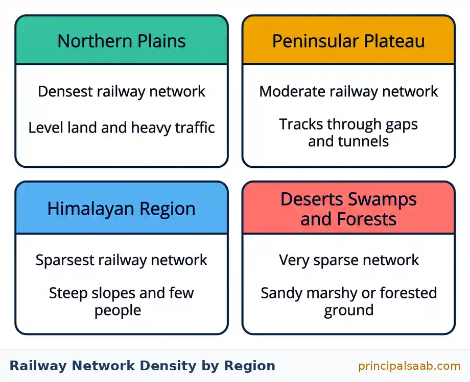
The distribution of the railway network is influenced by physiographic, economic and administrative factors. Let us take them region by region, and in each case ask the same two questions: is the land easy to lay track on, and is there enough traffic to justify the cost.
The Northern Plains: The Densest Network
The northern plains have the densest railway network in the country, and every reason for it is visible on a relief map. The land is vast and level, so track can be laid cheaply and straight. The population density is very high, so passenger demand is enormous. Agriculture is rich and productive, so there is a great deal of grain, sugarcane and produce to move. Industry and urban centres are numerous, generating freight in both directions. Level land plus dense population plus rich agriculture equals dense railway. That is the equation.
But there is a catch, and it is the detail that separates a good answer from an average one. The northern plains are crossed by a large number of rivers, and every river needs a bridge. Bridges are expensive and slow to build. So the plains are favourable overall, yet the rivers impose a real constraint. Mentioning that tension shows you have understood rather than memorised.
The Peninsular Plateau: Tracks Through Gaps And Tunnels
In the hilly terrain of the peninsular region, railway tracks are laid through low hills, gaps or tunnels. The plateau is not flat, but it is old, worn down and crossed by valleys and passes, so engineers can find a route through rather than over. The network here is moderate rather than dense: less level land than the plains, but far more workable than the Himalayas, and there is real mineral and industrial traffic to carry.
The Himalayan Region: The Sparsest Network
The Himalayan mountainous regions are unfavourable for railway construction, and here you should give three reasons together, because they reinforce one another. First, the terrain is extremely difficult: steep gradients, deep gorges, unstable slopes and heavy snow make construction and maintenance very costly. Second, the population is sparse, so there are few passengers. Third, there is a lack of economic opportunities, so there is little freight. Notice how the second and third reasons are economic, not physical. Even if you could build the line, there might not be enough traffic to justify it. That is the deeper point: railways need both buildable land and paying traffic.
The Difficult Middle Cases
- The sandy plain of western Rajasthan. Shifting sand, extreme temperatures and a sparse population make it unfavourable for a dense network.
- The swampy and marshy tracts of Gujarat, including the marshy Rann area, where waterlogged ground is unsuitable for stable track.
- The forested and hilly tracts of Madhya Pradesh, Odisha and Jharkhand, where dense forest, uneven relief and scattered settlement all raise costs, even though these regions are mineral-rich and therefore have important freight lines cutting through them.
- The Konkan Railway along the west coast is a superb case study. It was a major engineering achievement, opening up a difficult coastal strip between the Western Ghats and the Arabian Sea. But it has faced problems including the sinking of the track in some stretches and landslides during heavy monsoon rain. That is a beautiful illustration of geography fighting back after the engineers have gone home.
For any region, ask: (1) Can you build here? This is the relief filter: level land yes, mountains and swamps and shifting sand no. (2) Is there enough traffic? This is the economic filter: dense population, rich agriculture, industry and minerals yes, sparse and subsistence populations no. A region needs to pass both filters to get a dense network. The northern plains pass both. The Himalayas fail both. Western Rajasthan fails both, for different reasons. Learn the test and you can answer about any region.
Northern plains, dense network:
(i) The land is vast and level, so tracks can be laid easily and at relatively low cost. [1]
(ii) The population density is very high and agriculture is rich and productive, so there is heavy demand for both passenger and freight movement. [1]
(iii) Numerous industrial and urban centres generate large volumes of goods traffic in both directions. [1]
Himalayan region, sparse network:
(iv) The terrain is steep, rugged and unstable, with deep gorges and heavy snowfall, which makes construction and maintenance extremely difficult and expensive. [1]
(v) The population is sparse and economic opportunities are limited, so there is not enough passenger or freight traffic to justify the cost of building lines. [1]
Optional extra that impresses: even the favourable plains face one obstacle, the large number of rivers that must be bridged.
Why it works: the answer is split under two clear sub-headings, so the examiner can find three marks in one place and two in another without hunting. In a 5-mark comparison, always sub-head. It costs you five seconds and protects every mark.
The Konkan Railway runs along the western coastal strip between the Western Ghats and the Arabian Sea, a region of rugged relief crossed by many rivers and steep spurs, so building it required extensive tunnelling and bridging and it opened up a previously poorly connected coastal belt. [1]
Despite this achievement, some stretches have suffered from the sinking of the track, because the ground beneath is soft and unstable in places. [1]
The route also experiences landslides during the heavy monsoon rainfall of the west coast, which disrupt services and require constant maintenance. [1]
Why it works: the word yet in the question signals a contrast. One mark for the achievement, two for the difficulties. Read the connecting words in a question; they tell you how to divide your answer.
Pipelines: The Quiet Transport System
Pipelines are the mode nobody thinks about, which is exactly why they show up in exams. There is no driver, no timetable, no station and no traffic jam. A pipeline is transport with the transport taken out: the goods move and nothing else does.
Pipelines are a relatively new arrival on the transportation map of India. In the past they were used mainly to carry water to cities and industries. Today their most important use is to transport crude oil, petroleum products and natural gas from oil and natural gas fields to refineries, fertiliser factories and big thermal power plants. Learn that trio of destinations, because questions often ask what pipelines connect.
Here is the detail that surprises students and delights examiners: solids can also be transported through pipelines after being converted into slurry, that is, finely ground and mixed with water so the mixture flows. Coal slurry pipelines are the standard example. So a pipeline is not restricted to liquids and gases.
The Economics Of A Pipeline
Three advantages, and they fit together into one story. The initial cost of laying pipelines is high, but the subsequent running costs are minimal. Once the pipe is in the ground there is no fuel for vehicles, no crew, no return journey with an empty vehicle. It rules out trans-shipment losses and delays, meaning the product is never unloaded from one vehicle and reloaded into another, so nothing is spilt, evaporated, pilfered or held up in a queue. And it operates continuously, day and night, in all weather, which no road or rail service can match.
The disadvantages follow from the same facts. A pipeline is completely inflexible: it goes from exactly one place to exactly one place and can never be rerouted. It carries only one kind of product. It is expensive and slow to repair when it leaks or is damaged, and detecting a leak underground is difficult. And a leak of oil or gas causes serious environmental damage.
Trans-shipment is transferring a cargo from one carrier to another during a journey, for example from ship to lorry to train. Every transfer costs money, takes time and risks loss or damage. A pipeline has zero transfers between its two ends, which is why the phrase rules out trans-shipment losses and delays is the single strongest advantage you can quote.
The Three Important Pipeline Networks Of India
Learn these three by their end points. The intermediate towns are useful detail but the end points are what get asked.
- From upper Assam to Kanpur in Uttar Pradesh, passing through Guwahati, Barauni and Allahabad. It has branches from Barauni to Haldia by way of Rajbandh, from Rajbandh to Maurigram, and from Guwahati to Siliguri. Think of this as the eastern crude oil line, running from the oilfields of the north-east westwards into the Gangetic plain.
- From Salaya in Gujarat to Jalandhar in Punjab, passing through Viramgam, Mathura, Delhi and Sonipat, with branches connecting Koyali near Vadodara in Gujarat, Chakshu and other places. This is the western line, running from the Gujarat coast north-west into Punjab.
- The gas pipeline from Hazira in Gujarat to Jagdishpur in Uttar Pradesh, passing through Vijaipur in Madhya Pradesh, with branches to Kota in Rajasthan and to Shahjahanpur, Babrala and other places in Uttar Pradesh. This is the famous HVJ line, and the letters give you the three key places: Hazira, Vijaipur, Jagdishpur.
The third pipeline has a built-in mnemonic sitting inside its own name: Hazira to Vijaipur to Jagdishpur, the HVJ gas pipeline. Also note it is the only one of the three that is specifically a gas pipeline, and that Vijaipur is in Madhya Pradesh while both ends are not. Three states in one line: Gujarat, Madhya Pradesh, Uttar Pradesh.
Advantages
(i) The initial cost of laying a pipeline is high, but the subsequent running cost is minimal, which makes it very economical over the long term. [1]
(ii) It rules out trans-shipment losses and delays, because the material is never unloaded and reloaded between the two ends of the journey. [1]
(iii) It works continuously, in all weather and at all hours, without crew, traffic congestion or empty return journeys, and it can carry liquids, gases and even solids once they are converted into slurry. [1]
Limitation
(iv) A pipeline is completely inflexible, since it serves only two fixed points and can carry only one type of material, and any leak or damage is difficult to detect and expensive to repair, besides causing environmental harm. [1]
Why it works: the question asked for three plus one, so the answer is laid out as three plus one under headings. Never make the examiner count for you; count for them.
Waterways And The National Waterways
Waterways are the cheapest mode of transport, and I want you to understand why rather than just remember that they are, because the reason is genuinely elegant.
A road has to be built and a railway line has to be laid, and both then have to be maintained against rain, heat and use. A river is already there. Nobody built the Ganga. So the natural track costs nothing to construct. On top of that, water supports the weight of the vessel, so an engine does not have to fight friction with the ground the way a wheel does; it only has to push the boat forward through water. That means a barge can carry an enormous, heavy load using relatively little fuel. Cheap track plus low fuel per tonne equals the cheapest transport there is.
Cheapest for heavy and bulky goods, fuel-efficient, and environment friendly. Those three together are the standard mark-earning trio. The trade-off, which you should also be ready to state, is that waterways are very slow and can only go where the water goes, so they suit non-urgent bulk cargo and are useless for anything perishable or urgent.
India has inland navigation waterways of roughly 14,500 kilometres in total length, of which only a portion, in the region of 5,700 kilometres, is navigable by mechanised vessels. Treat both figures as approximate. The gap between the two numbers is itself the point: having a river is not the same as having a usable waterway. Silting, seasonal variation in flow, shallow stretches, and the diversion of water for irrigation all reduce how much of a river a loaded barge can actually use.
The National Waterways
Certain stretches have been declared National Waterways because of their importance for inland navigation. The ones your textbook drills are these, and I have given lengths as approximate because they are quoted slightly differently in different editions.
| Waterway | Stretch | Approximate length | Where it is |
|---|---|---|---|
| National Waterway No. 1 | The Ganga river between Allahabad (Prayagraj) and Haldia | About 1,620 km | Northern plains, ending at the Bengal coast. The longest of the set. |
| National Waterway No. 2 | The Brahmaputra river between Sadiya and Dhubri | About 891 km | Assam and the north-east, where roads and rail are hardest to build. |
| National Waterway No. 3 | The West Coast Canal in Kerala, from Kottapuram to Kollam, with the Udyogamandal and Champakkara canals | About 205 km | Kerala backwaters. The only canal-based one in the core list. |
| National Waterway No. 4 | Specified stretches of the Godavari and Krishna rivers, together with the Kakinada to Puducherry stretch of canals | About 1,078 km | Andhra Pradesh, Telangana, Tamil Nadu and Puducherry, on the east coast. |
| National Waterway No. 5 | Specified stretches of the Brahmani river with the Matai river, the delta channels of the Mahanadi and Brahmani rivers, and the East Coast Canal | About 588 km | Odisha and West Bengal, on the east coast. |
If your revision time is short, the three that appear most often are NW1 (Ganga, Allahabad to Haldia), NW2 (Brahmaputra, Sadiya to Dhubri) and NW3 (West Coast Canal, Kerala). A neat way to hold them: one great northern river, one great north-eastern river, one southern canal system. Also be aware that Parliament later declared a much larger number of national waterways under the National Waterways Act of 2016, so a current news article may mention over a hundred. For your exam, answer with the list in your prescribed textbook.
Besides these, several other rivers and backwaters carry local boat traffic, particularly in Kerala, Goa, West Bengal and Assam, and coastal shipping along India’s long coastline moves bulk cargo between ports. Coastal shipping deserves a line of its own: because peninsular India is surrounded by sea on three sides, moving goods by ship between, say, Gujarat and Tamil Nadu can be cheaper than sending them overland, and it reduces the load on congested roads and railways.
(i) The waterway itself is natural and does not have to be constructed, so unlike roads and railways there is no expense of building and maintaining a track. [1]
(ii) Water supports the weight of the vessel, so very heavy and bulky goods can be carried using comparatively little fuel, which makes the cost per tonne carried extremely low. [1]
(iii) It is fuel-efficient and environment friendly, releasing less pollution per tonne of cargo than road or rail transport, and a single vessel replaces a very large number of trucks. [1]
Why it works: the command word is justify, which means the statement is given as true and your job is to supply evidence for it. Do not spend a line agreeing with the statement; go straight to the evidence. Also notice reason (i) is about the track, (ii) about the vehicle, (iii) about the environment. Three different angles again.
Inland waterways are rivers and canals inside the country used for navigation. Sea ports are places on the coast where ocean-going ships load and unload. Haldia is a nice trap because it appears in both stories: it is the sea-facing end of National Waterway No. 1 and a major sea port. Know which role the question is asking about.
Major Sea Ports Of India
Now we reach the heart of the chapter for exam purposes. The ports appear twice on this page: here, where we learn what each one is and does, and again in the map drill, where we learn exactly where to put the dot. Read this section for understanding. Do the drill for marks. You need both, but if you are short of time, understanding first makes the drill stick far better.
India has a very long coastline, and with the peninsula projecting into the Indian Ocean it sits astride some of the world’s busiest sea routes. India has twelve major ports, together with around two hundred notified minor and intermediate ports. Major ports are administered centrally; minor and intermediate ports come under the state governments. Sea ports handle the overwhelming majority of India’s foreign trade by volume, which is why they matter economically far more than their number suggests.
A harbour is the sheltered stretch of water where ships can lie safely. A port is the harbour plus the docks, cranes, warehouses and road and rail links that let cargo be handled. A hinterland is the inland area that a port serves, sending its exports out through that port and receiving its imports through it. A port thrives when it has a good natural harbour and a rich hinterland. Visakhapatnam has the harbour; Kolkata and Haldia have the hinterland of the Ganga plain behind them. Use the word hinterland in a long answer and it lifts the whole thing.
Going Down The West Coast
- Kandla, in Gujarat. A tidal port in the Kachchh region, developed soon after Independence specifically to take the pressure off Mumbai and to replace the trade lost when Karachi went to Pakistan at Partition. It handles a great deal of petroleum, petroleum products and fertiliser, and it serves the vast hinterland of Gujarat, Rajasthan, Punjab, Haryana, Jammu and Kashmir and western Uttar Pradesh. It has since been renamed Deendayal Port, so you may meet either name.
- Mumbai, in Maharashtra. India’s biggest port, with a natural, spacious and well-sheltered harbour. It handles a huge share of the country’s trade. Nearby, at Navi Mumbai, the Jawaharlal Nehru Port was developed as a satellite to relieve congestion at Mumbai and it is India’s largest container-handling port.
- Marmagao, in Goa. A premier iron ore exporting port, historically handling a very large share of India’s iron ore exports.
- New Mangalore, in Karnataka. Caters especially to the export of iron ore concentrates from the Kudremukh mines of Karnataka.
- Kochi, in Kerala. The extreme south-western port, with a superb natural harbour located at the head of a lagoon, in the Vembanad backwaters. Its position gives it an advantage on routes to West Asia, Africa and Europe.
Coming Back Up The East Coast
- Tuticorin, in Tamil Nadu. At the extreme south-east of the peninsula, with a natural harbour and a rich hinterland, handling a great variety of cargo including coal, salt, foodgrains, edible oils, sugar, chemicals and petroleum products. It has been renamed V. O. Chidambaranar Port.
- Chennai, in Tamil Nadu. One of the oldest artificial ports of the country, and historically second only to Mumbai in importance. Because it is artificial rather than naturally sheltered, it is not a deep-water harbour, but it has served the south for a very long time.
- Visakhapatnam, in Andhra Pradesh. The deepest landlocked and well-protected port in the country, originally developed to handle the export of iron ore. Its natural protection is the detail examiners like.
- Paradip, in Odisha. Specialises in the export of iron ore from the mineral-rich hinterland of Odisha and Jharkhand.
- Haldia, in West Bengal. A subsidiary port developed to relieve the growing pressure on the Kolkata port. It sits on the Hooghly, downstream of Kolkata, where deeper water lets larger ships berth.
Kandla, a tidal port in Kachchh in Gujarat, was developed soon after Independence to ease the pressure on Mumbai port and to make up for the loss of Karachi, which went to Pakistan at Partition. [1]
It serves a very large hinterland covering Gujarat, Rajasthan, Punjab, Haryana and western Uttar Pradesh, and handles large quantities of petroleum, petroleum products and fertilisers. [1]
Haldia, in West Bengal, is important because it was developed as a subsidiary port to relieve the growing congestion at Kolkata port; being downstream on the Hooghly it has deeper water and can take larger vessels. [1]
Why it works: both ports exist for the same underlying reason, to relieve pressure on an older port, and saying so shows you have seen the pattern rather than memorised two facts. Patterns are what turn a 2-mark answer into a 3-mark one.
Airways: Domestic, International, Advantages And Limits
Air transport is the fastest, most comfortable and most prestigious mode of transport. That is the standard opening line and it is worth using, but I want you to look past it, because the geographically interesting thing about aviation in India is not speed. It is access.
Aircraft can cover difficult terrains that defeat every surface mode: high mountains, dry deserts, dense forests and long oceanic stretches. A road must be cut into a mountain and a railway must be tunnelled through it. An aeroplane simply goes over. This is why air travel matters most exactly where the ground is worst.
The north-eastern states are the textbook case. They are cut off by the presence of big rivers, dense forests, frequent floods and international boundaries, and connected to the rest of India only through a narrow corridor. Building and maintaining roads and railways there is slow, expensive and repeatedly disrupted. So air travel there is not a luxury for the rich; for passengers, mail, medical evacuation and urgent supplies it is a genuine lifeline. If a question asks why air transport is especially important in a particular region, the answer is almost always about terrain, isolation and the failure of surface modes.
How Air Transport Is Organised
Air transport in India was nationalised in 1953. Under that arrangement, Air India provided international services while Indian Airlines, along with Alliance Air, provided domestic services and services to neighbouring countries. The carriers have since been restructured and merged, and private airlines now carry a very large share of domestic traffic, so describe the historical arrangement in the past tense and do not present it as the current market. Pawan Hans Helicopters Limited provides helicopter services, notably to the Oil and Natural Gas Commission for its offshore operations, and in inaccessible areas and difficult terrains such as the north-eastern states and the interior parts of Jammu and Kashmir, Himachal Pradesh and Uttarakhand.
A more recent development worth a sentence in a long answer is the regional connectivity scheme popularly called UDAN, which aims to make air travel affordable and to bring smaller and unserved airports into use, so that flying is not confined to the largest cities. This shows the direction of policy: not just faster travel between metros, but wider access.
Advantages And Limits, Honestly Stated
- Advantages: by far the fastest mode; reaches inaccessible terrain; essential for perishable and high-value low-bulk goods such as medicines, electronics, cut flowers and precision instruments; indispensable for disaster relief, medical evacuation and defence; and it links India to the rest of the world for trade, tourism and business.
- Limits: it is very costly, so it remains out of reach of ordinary people for regular travel; it has limited carrying capacity, so it cannot move heavy, bulky, low-value goods like coal or iron ore economically; it is badly affected by bad weather, fog in particular disrupting north Indian airports in winter; it needs expensive infrastructure in the form of airports, runways and navigation systems; and it consumes a great deal of fuel per tonne carried and contributes significantly to pollution.
Best at what? Air is best for speed and access. It is the worst choice for heavy bulk cargo, where it is hopelessly expensive. Waterways are cheapest, roads give door-to-door service, rail carries bulk over land, pipelines run continuously. In any comparison answer, tie each mode to the job it is good at. A mode is never good or bad in the abstract; it is good for something.
Why it is not affordable:
(i) Air travel is very costly compared with road and rail, because aircraft, airports, fuel and skilled crew all involve high expense, which is passed on in fares. [1]
(ii) Its carrying capacity is limited, so it cannot achieve the low cost per passenger or per tonne that bulk surface transport achieves. [1]
Why it is nevertheless indispensable, especially in the north-east:
(iii) The north-eastern region is difficult to reach by surface transport because of high relief, dense forests, big rivers and repeated flooding, and it is connected to the rest of the country only through a narrow corridor. [1]
(iv) Building and maintaining roads and railways there is slow, expensive and frequently disrupted, so air services provide the only quick and reliable link for passengers, mail and urgent cargo. [1]
(v) Air transport is also essential there for medical emergencies, relief operations during floods and landslides, and the movement of defence personnel to border areas, which surface transport cannot deliver in time. [1]
Why it works: the question contains a contradiction, expensive yet essential, so the answer must resolve it rather than pick a side. Two marks for the first half, three for the second, with a heading each. Whenever a question says yet or although, write both halves.
Communication: Personal And Mass
Everything so far has moved objects and people. Now we move something weightless: information. And here is the thing that makes communication so powerful. When you carry a sack of rice from Punjab to Kerala, Punjab has one less sack. When you send an idea from Punjab to Kerala, Punjab still has the idea. Information is the one thing that can be given away without being lost, which is why communication networks change economies faster than transport networks do.
The syllabus divides communication into two clean categories, and you should be able to define and illustrate both.
- Personal communication is one person to one person, or to a small known group. It is private and usually two-way. Examples: letters, telephone calls including mobile phones, telegram in the past, e-mail, and personal messaging over the internet.
- Mass communication is one source to a very large, general and mostly unknown audience. It is public and usually one-way. Examples: radio, television, newspapers, magazines, books and films.
Ask: do I know who receives this? If you know exactly who is on the other end, it is personal communication. If the message goes out to whoever happens to be listening, watching or reading, it is mass communication. A phone call to your cousin, personal. A radio broadcast heard by millions, mass. A newspaper, mass, even though you personally bought that one copy.
The Indian Postal Network
India has the largest postal network in the world, handling parcels as well as personal written communication. The system splits mail into two classes, and this is worth learning precisely because it is exactly the sort of concrete detail that makes a good short answer.
- First class mail covers cards and envelopes. It is airlifted between stations covering both land and air, so it moves fast.
- Second class mail covers book packets, registered newspapers and periodicals. It is carried by surface mail, that is by land and water, so it is slower and cheaper.
To speed up delivery of bulk mail, the department introduced six specialised mail channels: the Rajdhani Channel, the Metro Channel, the Green Channel, the Business Channel, the Bulk Mail Channel and the Periodical Channel. Six names is a lot to hold, so here is a hook: two are about places (Rajdhani for the capital, Metro for the big cities), and four are about types of mail (Green, Business, Bulk Mail, Periodical).
The Telecom Network
India has one of the largest telecom networks in Asia. Two facts are worth quoting. First, the great majority of villages have been covered by telephone service, and Subscriber Trunk Dialling, or STD, facilities are available at a uniform rate all over India, so calling a distant city costs the same as calling a nearby one. That uniform rate is a quiet but genuine act of national integration; it means distance stopped being a penalty. Second, this was made possible by integrating the development in space technology with communication technology, that is, by using satellites. Mobile telephony and internet access have since expanded very rapidly, and India today has one of the largest bases of mobile and internet users in the world; I will leave that qualitative rather than quoting a number, since the figures move every quarter.
Personal communication takes place between individuals or within a small, known group and is generally private and two-way; examples are letters and telephone calls, including mobile calls and e-mail. [1]
Mass communication carries a message from a single source to a very large, general and largely unknown audience, and is generally public and one-way; examples are radio and television broadcasts, and newspapers. [1]
The essential difference is therefore the size and identity of the audience: in personal communication the sender knows the receiver, while in mass communication the message is addressed to the public at large. [1]
Why it works: the command word is distinguish, so the answer must state the point of difference explicitly, which the third line does. A pair of definitions alone often loses the final mark because the student never actually said what the difference is.
(i) A uniform rate means that the cost of a call no longer depends on distance, so a family can stay in touch with relatives working in a distant city without paying a penalty for that distance. [1]
(ii) It has helped migrant workers, traders and farmers, who can now obtain market prices, place orders and arrange work directly rather than relying on middlemen or travelling in person, which saves both money and time. [1]
(iii) It has strengthened national integration and emergency response, since people in remote areas can contact officials, hospitals and family anywhere in the country on the same terms as people in cities. [1]
Why it works: the question says ordinary people, so every point is about a household or a worker, not about the telecom industry. Answer the people in the question.
Print And Electronic Media In India
Mass communication in India runs on two legs, print and electronic, and the syllabus expects you to know what each does beyond simply entertaining people. The phrase to hold onto is this: mass media provides entertainment and creates awareness among people about various national programmes and policies. That second half is the part students forget, and it is the part that earns the mark.
Electronic Media: Radio And Television
All India Radio, also known as Akashwani, broadcasts a variety of programmes in national, regional and local languages for various categories of people, spread over different parts of the country. That multilingual reach is its defining strength: in a country of many languages, radio can speak to a farmer in her own language, cheaply, without her needing to be literate or to own an expensive device. Radio remains genuinely important for weather bulletins, agricultural advice and emergency information in rural areas.
Doordarshan, the national television broadcaster, is one of the largest terrestrial networks in the world. It broadcasts a variety of programmes ranging from entertainment to educational and sports content, for people of different age groups. Television combines sight and sound, so it can teach and persuade in ways print cannot, and it reaches people regardless of literacy.
Print Media: Newspapers, Magazines And Books
India publishes a very large number of newspapers and periodicals every year, in around a hundred languages and dialects, which is one of the most striking facts in the whole chapter. Of these, Hindi newspapers have the largest circulation, followed by English and then Urdu. Learn that order; it is asked. Print media matters because it can go into depth, can be re-read, can be kept as a record, and can carry detailed argument in a way a thirty-second broadcast cannot.
Films
India is the largest producer of feature films in the world. It produces feature films, short films, video feature films and video short films. The Central Board of Film Certification is the authority to certify both Indian and foreign films for public exhibition in India. Note the word certification, not censorship; the Board classifies films for audiences. And note that the Board certifies both Indian and foreign films, which is a detail that often forms the second half of a question.
Because it does economic work. Mass media spreads information about prices, weather, schemes, health and rights; it advertises goods and so creates demand and supports industry; it promotes tourism; it warns of cyclones and floods; and it binds a diverse country into a shared national conversation. It is infrastructure for ideas, exactly as a highway is infrastructure for goods. That is the link back to the word lifeline.
(i) It creates awareness among people about government programmes and policies, such as schemes for health, education, sanitation and agriculture, so that the benefits actually reach those they are meant for. [1]
(ii) It spreads useful practical information such as weather forecasts, market prices and warnings about floods and cyclones, which helps farmers plan and helps save lives during disasters. [1]
(iii) It promotes national integration and supports economic activity, since broadcasts and publications in many languages connect diverse regions, while advertising creates demand for goods and services and promotes tourism. [1]
Why it works: each point moves from the medium to a real consequence. Writing that radio gives entertainment earns nothing on a development question; writing that radio warns of cyclones and saves lives earns the mark. Always finish the sentence with the effect.
International Trade: Exports, Imports And Balance Of Trade
We now come to the section that matters most for your Economics papers later, so read it slowly even though it looks simple. Almost every mark lost here is lost on definitions, not on ideas.
Start from the beginning. Trade is the exchange of goods among people, states and countries. The market is the place where such exchange takes place. Trade between two countries is called international trade, and it may take place through sea, air or land routes. Trade within a city, town or village is local trade; trade between two or more states within a country is state-level or national trade.
Now the four terms you must be able to define in one line each, without hesitating.
| Term | Definition to write in the exam | How to remember it |
|---|---|---|
| Export | Goods and services sold by a country to other countries; goods going out. | Ex means out, as in exit. Goods exit the country. |
| Import | Goods and services bought by a country from other countries; goods coming in. | Im sounds like in. Goods come in. |
| Balance of trade | The difference between the value of a country’s exports and the value of its imports. | It is a subtraction, not a total. Exports minus imports. |
| Favourable balance of trade | When the value of exports exceeds the value of imports. | Selling more than you buy, so money flows in. |
| Unfavourable or adverse balance of trade | When the value of imports exceeds the value of exports. | Buying more than you sell, so money flows out. |
It is the difference, not the sum. And it is the difference in value, not in weight or in the number of items. A country could export a hundred shiploads of ore and import one shipload of aircraft parts and still have an unfavourable balance, because value is what is being compared. Say the word value in your definition and you protect the mark.
What India Exports And Imports
India has trade relations with all the major trading blocs and all geographical regions of the world. On the specific commodities, I want you to learn the categories rather than any numbers, because values swing violently from year to year with oil prices and exchange rates. Categories are stable; values are not.
- Major exports: agriculture and allied products; ores and minerals; gems and jewellery; chemicals and related products; engineering goods; petroleum products; and textiles and readymade garments. Engineering goods and petroleum products have grown in importance over time.
- Major imports: petroleum and petroleum products; pearls and precious stones; inorganic chemicals; gold and silver; machinery; fertilisers; and edible oils.
Look at those two lists side by side and one thing jumps out. Petroleum appears on both. India imports crude oil in very large quantities because it does not produce enough for its own needs, refines it, and exports refined petroleum products. That is a genuinely interesting economic fact and it makes an excellent line in an answer: India is a large importer of crude and a significant exporter of refined products, because refining adds value.
One more thing to know: India has emerged as a software giant at the international level and earns large amounts of foreign exchange through the export of information technology services. This is an invisible export, a service rather than a physical good, and it is a good example of how modern trade is not only about ships full of cargo.
Balance of trade is the difference between the total value of a country’s exports and the total value of its imports over a given period. [1]
A balance of trade is said to be favourable when the value of exports exceeds the value of imports. [1]
A consequence of a favourable balance is that the country earns more foreign exchange than it spends, which strengthens its reserves and can be used to fund development and to stabilise its currency. [1]
A balance of trade is said to be unfavourable or adverse when the value of imports exceeds the value of exports. [1]
A consequence of an unfavourable balance is that foreign exchange flows out of the country, which can drain reserves, put pressure on the value of the currency and increase dependence on borrowing. [1]
Why it works: the question has three tasks, define, distinguish and give consequences. The answer does all three in a fixed rhythm: definition, then favourable with its consequence, then unfavourable with its consequence. Structure is worth as much as content in a 5-mark answer.
India’s domestic production of crude oil is far less than its requirement, so large quantities of crude petroleum are imported, and this is one of the largest items in the import bill. [1]
India has a large refining capacity, so imported crude is processed in refineries into products such as diesel, petrol, kerosene and aviation fuel. [1]
A part of these refined petroleum products is then exported, so petroleum appears on both lists; the country imports the raw material and exports the processed product, and the difference between the two is the value added by refining. [1]
Why it works: the answer separates crude from refined. A student who writes only that India both buys and sells oil has not explained anything. The explanation lives entirely in the distinction between raw material and processed product.
Why Trade Is Called The Economic Barometer
This is a short section but it contains one of the most quotable lines in the syllabus, and it rests on an analogy that is worth unpacking properly.
A barometer measures air pressure. It does not cause the weather; it reveals it. You look at the barometer and you can tell what is coming, because pressure and weather move together. That is exactly the relationship between international trade and the health of an economy.
The advancement of a country’s international trade is an index of its economic prosperity, and it is therefore considered the economic barometer of that country. Learn that sentence. Then be ready to explain why it is true, because a good answer states the claim and then justifies it.
Why does trade reveal economic health? Think about what a country must have in order to export a lot. It must produce a surplus beyond its own consumption, which means productive agriculture or industry. It must produce goods of a quality and price that foreigners will actually choose, which means efficiency and technology. It must have ports, roads, railways and power to get those goods out, which means infrastructure. And it must have a stable enough system that foreign buyers trust it. So a country with rising exports must, almost by definition, have those things working. You cannot fake an export figure with a speech.
The same works in reverse. What a country imports also tells you about it. Heavy imports of machinery and industrial raw materials usually signal an economy that is building and expanding. Heavy imports of basic foodgrains may signal agricultural distress. So both sides of the trade account carry information, which is the deeper meaning of the barometer image.
There is a caution worth adding, and it shows real understanding if you include it: no country today can be self-sufficient in everything. Resources are unevenly distributed across the earth, and no nation has all the minerals, climates and skills it needs. So trade is not optional and not a sign of weakness; it is how countries make use of the fact that different places are good at different things. That is why trade is described as the economic barometer, not the economic disease.
A barometer indicates the condition of the atmosphere without causing it, and in the same way the state of a country’s international trade indicates the condition of its economy; the advancement of a country’s international trade is an index of its economic prosperity. [1]
A country can export in large volume only if it produces a surplus beyond its own needs and produces goods of a standard and price that other countries are willing to buy, which shows that its agriculture, industry, technology and infrastructure are working well. [1]
The pattern of imports is equally revealing, since large imports of machinery and industrial raw materials indicate an expanding economy, while heavy imports of basic foodgrains may indicate weakness in agriculture; and since no country is self-sufficient in all resources, the volume and composition of trade together reflect the country’s overall economic strength. [1]
Why it works: mark one explains the metaphor, mark two uses exports as evidence, mark three uses imports as evidence. Most students only write about exports and stop at two marks. The imports half is the easy extra mark almost nobody takes.
Tourism As A Trade And An Employment Generator
Here is a question that stops most students for a moment: why is tourism called a trade at all? Nothing is shipped. No container leaves the port. A visitor arrives, looks at a fort, eats a meal, buys a scarf and goes home. Where is the trade?
The answer is the loveliest idea in this chapter. In ordinary trade, the goods travel to the customer. In tourism, the customer travels to the goods. A foreign tourist who spends money in Jaipur has bought Indian services, hotel rooms, meals, guiding, transport, handicrafts, exactly as if those things had been shipped abroad and sold there. Foreign currency comes into India and Indian services go out of Indian hands. That is an export in everything but appearance, which is why tourism is called an invisible trade and why its earnings count as foreign exchange.
An invisible item of trade is a service rather than a physical good. Tourism and software services are the two examples this chapter gives you. In both cases India earns foreign exchange without a single crate crossing a port. If a question asks how tourism helps the economy, the phrase earns valuable foreign exchange should appear in your first line.
Why Tourism Is Such A Powerful Employment Generator
Tourism has grown substantially in India over the past few decades. On figures, I will be careful with you: the standard textbook quotes around five million foreign tourist arrivals in 2010 and states that more than fifteen million people are directly engaged in the tourism industry. Those are 2010-era figures. Arrivals fell very sharply in 2020 and 2021 and have been recovering since, so if you want to quote a number, date it and call it approximate, or better, describe the trend and the mechanism instead. Examiners reward mechanism; they rarely require a number.
The mechanism is what makes tourism special, and it is worth understanding rather than memorising. Tourism spreads its money wide and shallow instead of narrow and deep. A large factory employs many people in one place with one skill. A tourist season pays a hotel cleaner, a taxi driver, a cook, a guide, a boatman, a weaver, a potter, a shopkeeper, a musician and a farmer selling vegetables to the hotel, all in the same district, most of them needing no formal qualification and no large capital. It supports local handicrafts and cultural pursuits directly, which means it can sustain traditional skills that would otherwise die out for lack of a market. And crucially it can create income in places that have no industrial potential at all: a desert village, a hill valley, a coastal fishing settlement.
The Types Of Tourism
Foreign tourists come to India for a range of purposes, and the syllabus names these types. Learn all six, because a question may ask you to name and illustrate them.
- Heritage tourism — historical monuments, forts, temples and world heritage sites.
- Eco tourism — national parks, wildlife sanctuaries, biosphere reserves and natural landscapes, visited in a way that aims not to damage them.
- Adventure tourism — trekking, mountaineering, river rafting, skiing and desert safaris.
- Cultural tourism — festivals, fairs, classical music and dance, crafts and cuisine.
- Medical tourism — travelling to India for treatment, because quality care is available at a much lower cost than in many countries.
- Business tourism — travel for conferences, trade fairs, exhibitions and business meetings.
Rajasthan, Goa, Jammu and Kashmir, and the temple towns of south India are among the important destinations for foreign tourists, and each illustrates a different type: Rajasthan for heritage and culture, Goa for coastal leisure, Jammu and Kashmir for landscape and adventure, the southern temple towns for heritage and pilgrimage.
Beyond money, tourism does two other things the syllabus asks about. It promotes national integration, because Indians travelling within their own country meet ways of life different from their own. And it develops international understanding about our culture and heritage, since a visitor who has walked through an Indian city carries home an impression no advertisement could create.
In a long answer, a sentence acknowledging that unplanned tourism can strain water supply, generate waste and damage fragile ecosystems and heritage sites shows balanced thinking, and it explains why eco tourism is named as a separate category in the first place. One sentence is enough; do not turn the answer into an essay against tourism.
(i) Tourism is called a trade because tourists purchase Indian services such as accommodation, food, transport, guiding and handicrafts, and foreign tourists pay for these in foreign currency, so the country earns valuable foreign exchange exactly as it would from exporting goods. [1]
(ii) It is described as an invisible trade because what is sold is a service rather than a physical commodity, and nothing leaves the country through a port; instead the customer comes to the product. [1]
(iii) Tourism generates employment on a very large scale and across a wide range of occupations, including hotel and restaurant staff, taxi and bus drivers, guides, boatmen, shopkeepers and performers, and the textbook estimates that more than fifteen million people are directly engaged in the industry. [1]
(iv) It gives direct support to local handicrafts and cultural pursuits, providing a market for weavers, potters, artisans and folk performers whose traditional skills might otherwise decline for want of buyers. [1]
(v) It creates income in regions that have little industrial potential, such as desert, hill and coastal areas, and it also promotes national integration and builds international understanding of Indian culture and heritage. [1]
Why it works: the first two marks answer why it is a trade and the last three answer how it creates employment. Two commands, two blocks. Also notice that point (v) covers regional development and integration, which lets a single answer serve several possible versions of this question.
Comparing All Five Modes Of Transport
Before we go to the map, let us put all five modes on one page, because comparison questions are common and because seeing them together fixes each one in place. Read the table across the rows, then cover a column and test yourself.
| Mode | Best suited for | Main advantages | Main limitations |
|---|---|---|---|
| Roadways | Short and medium distances; perishable goods; the first and last mile of every journey | Low construction cost; can cross hilly and dissected terrain and steep gradients; door-to-door service; low loading and unloading cost; acts as a feeder to rail, air and sea | Congestion and accidents; high cost per tonne over long distances; much of the network is unsurfaced and inadequate for the traffic; pollution |
| Railways | Heavy and bulky goods over long distances; mass passenger movement | Very low cost per tonne over long distances; fuel-efficient; carries huge volumes; supports national integration and long-distance travel by ordinary people | Very high construction cost; cannot be built easily in mountains, swamps and shifting sands; fixed routes only; ticketless travel, theft, chain pulling and congestion |
| Pipelines | Crude oil, petroleum products, natural gas, and solids converted into slurry | Very low running cost once laid; rules out trans-shipment losses and delays; operates continuously in all weather without crew or empty return trips | Very high initial cost; completely inflexible, serving only two fixed points and one product; leaks are hard to detect, costly to repair and environmentally damaging |
| Waterways | Heavy, bulky, non-urgent cargo along rivers, canals and the coast | The cheapest mode; the track is natural and needs no construction; highly fuel-efficient and environment friendly | Very slow; restricted to where navigable water exists; affected by silting, seasonal flow and diversion of water; useless for perishable or urgent goods |
| Airways | Urgent, perishable and high-value low-bulk goods; long-distance passengers; inaccessible regions | Fastest and most comfortable; crosses high mountains, deserts, dense forests and oceans; essential for relief, medical evacuation and defence; links India to the world | Very costly and beyond the reach of most people; small carrying capacity, so unsuitable for bulk goods; disrupted by bad weather and fog; expensive infrastructure; high fuel use and pollution |
(a) Rail to the port and then sea transport. Iron ore is extremely heavy and bulky and is not perishable or urgent, so the deciding factor is the lowest cost per tonne; rail carries it economically to a port such as Paradip, and ocean shipping carries it overseas at the lowest cost of all. [1]
(b) Air transport. Flowers are highly perishable and light in weight but high in value, so speed matters more than cost, and only air transport can deliver them fresh across an international distance within hours. [1]
(c) Road transport. The distance is short, the load is small and perishable, and the goods must be collected from the field and delivered to the market, which requires door-to-door service that no other mode can provide. [1]
Why it works: each choice names the deciding property of the cargo, that is bulk, perishability or distance, and then matches it to the strength of the mode. That is the reasoning pattern for every transport-choice question you will ever meet. Cargo first, mode second.
Map Skill Drill: The Official Locate And Label List
This is the section that pays. Everything above was for understanding and for your school papers. This is where your Board marks from this chapter actually come from, so I want you to give it your best attention, not your last twenty minutes.
Under the CBSE Class X Social Science curriculum 2026-27, the map work for this chapter is Locating and Labelling of the following, and nothing else:
Major Sea Ports (10): Kandla, Tuticorin, Mumbai, Chennai, Marmagao, Visakhapatnam, New Mangalore, Paradip, Kochi, Haldia.
International Airports (6): Amritsar (Raja Sansi, now Sri Guru Ram Das Ji), Delhi (Indira Gandhi), Mumbai (Chhatrapati Shivaji), Chennai (Meenambakkam), Kolkata (Netaji Subhash Chandra Bose), Hyderabad (Rajiv Gandhi).
Sixteen items in total. That is the entire Board-examinable content of this chapter. Sixteen dots on a map. It is a genuinely small list, and every single one of them is learnable in an afternoon. In recent papers the Social Science map question has carried around 5 marks in total, shared between History identification and Geography locating and labelling, so check your current sample paper for the exact split.
Step 1: Learn The Coastline As A Loop, Not A List
Do not try to memorise ten ports as ten separate facts. That is the slow way and it falls apart under exam pressure. Instead, notice something rather beautiful about the official list: five of the ten ports are on the west coast and five are on the east coast, and within each coast they fall in perfect geographical order. Once you see this, you are not memorising a list; you are tracing a finger around the edge of India.
Put your finger at the top-left of the map of India, on the Gujarat coast, and travel southwards down the west coast:
- Kandla — Gujarat
- Mumbai — Maharashtra
- Marmagao — Goa
- New Mangalore — Karnataka
- Kochi — Kerala
Look at that. Gujarat, Maharashtra, Goa, Karnataka, Kerala. That is simply the west-coast states in order from north to south, one port each, no exceptions and no gaps. Now round the southern tip and travel northwards up the east coast:
- Tuticorin — Tamil Nadu (far south-east)
- Chennai — Tamil Nadu
- Visakhapatnam — Andhra Pradesh
- Paradip — Odisha
- Haldia — West Bengal
Tamil Nadu, Tamil Nadu, Andhra Pradesh, Odisha, West Bengal. Again, simply the east-coast states in order from south to north, with Tamil Nadu getting two because it has both a southern and an eastern face.
Down the west: Kandla, Mumbai, Marmagao, New Mangalore, Kochi. Up the east: Tuticorin, Chennai, Visakhapatnam, Paradip, Haldia.
Say it as one loop, anticlockwise around the peninsula, starting at Gujarat. Ten ports, five and five, in strict geographical order. If you can recite this loop, you can never place a port on the wrong coast, which is the single most expensive mistake in this map question. Practise it right now, out loud, three times.
Step 2: The Complete Sea Port Table
This is the most valuable revision asset on this page. Cover the last three columns, read the port name, and say the state, the coast and the hook out loud. Then uncover and check. Do this until you get ten out of ten twice in a row on two different days.
| Sea port | State | Coast | Memory hook and what to say about it |
|---|---|---|---|
| Kandla (Deendayal Port) | Gujarat | West | Kandla in Kachchh — two hard K sounds, and it sits in the top-left corner of the map above the Gulf of Kachchh. A tidal port, developed after Partition to replace Karachi and relieve Mumbai. The northernmost port on the list. |
| Mumbai | Maharashtra | West | Mumbai in Maharashtra — two M sounds. India’s biggest port, with a natural, spacious and well-sheltered harbour. Roughly halfway down the west coast, and the only city on this list that is also an international airport. |
| Marmagao (Mormugao) | Goa | West | Marmaga-o goes with G-o-a — both end in the same vowel sound, and Goa is India’s smallest coastal state so there is only one place it can be. The premier iron ore exporting port. |
| New Mangalore | Karnataka | West | The name gives you the city, and Mangalore is in Karnataka. Handles iron ore concentrates from the Kudremukh mines. Kudremukh and Karnataka both begin with a K sound — a useful double link. |
| Kochi | Kerala | West | Kochi in Kerala — K and K again. The extreme south-west, a natural harbour at the head of a lagoon in the Vembanad backwaters. The last port before you round the tip of India. |
| Tuticorin (V. O. Chidambaranar Port) | Tamil Nadu | East | T for Tuticorin, T for Tamil Nadu, T for the toe of India. The extreme south-east, just after you round the tip. Natural harbour with a rich hinterland, handling a very varied cargo. |
| Chennai | Tamil Nadu | East | The capital of Tamil Nadu, so you already know where it is. One of the oldest artificial ports in the country. Like Mumbai, it is also on the international airport list, so learning it serves double duty. |
| Visakhapatnam | Andhra Pradesh | East | Known as Vizag. The deepest landlocked and well-protected port in India. Sits alone on the long Andhra coast between Chennai and Odisha, so there is little room for error. |
| Paradip | Odisha | East | Paradip in the delta, Odisha. Near the Mahanadi delta. Specialises in the export of iron ore from the mineral belt of Odisha and Jharkhand behind it. |
| Haldia | West Bengal | East | Haldia on the Hooghly, helping Kolkata. Three H sounds. A subsidiary port built to relieve pressure on Kolkata. The northernmost port on the east coast, right at the top of the Bay of Bengal. |
Step 3: The International Airports
Six airports, and this list is easier than the ports for one very good reason: every one of them is a city you already know. There is no obscure town here. Amritsar, Delhi, Mumbai, Chennai, Kolkata, Hyderabad. If you can find those six cities on a map of India, you have already done the hard part. The only new work is attaching the official name to each.
Notice also the geographical spread, which is a memory aid in itself. Amritsar is in the far north-west near the Pakistan border, in Punjab. Delhi is inland, in the north. Mumbai is on the west coast. Chennai is on the east coast in the south. Kolkata is in the east. Hyderabad is the only one in the interior of the peninsula, on the Deccan plateau. So: one north-west, one north, one west, one south-east, one east, one interior. Six directions, six airports.
| City | Official name of the airport | State or territory | Where it is and how to hold it |
|---|---|---|---|
| Amritsar | Sri Guru Ram Das Ji International Airport (long known as Raja Sansi) | Punjab | Far north-west, close to the international border with Pakistan. The only one of the six in the north-west, so it is unmistakable on a blank map. Both names are in use, so either is safe. |
| Delhi | Indira Gandhi International Airport | National Capital Territory of Delhi | Northern India, inland on the Yamuna, in the middle of the northern plains. India’s busiest airport. The easiest dot on the entire map. |
| Mumbai | Chhatrapati Shivaji Maharaj International Airport | Maharashtra | West coast, roughly halfway down. Also a major sea port, so one dot in your memory earns marks in two different questions. |
| Chennai | Chennai International Airport, at Meenambakkam | Tamil Nadu | South-east coast, capital of Tamil Nadu. Meenambakkam is the locality the airport stands in. Also a major sea port — the second of your double-duty cities. |
| Kolkata | Netaji Subhash Chandra Bose International Airport | West Bengal | Eastern India, on the Hooghly. Note that Kolkata is on the airport list but Haldia is the port from the same state — do not swap them. |
| Hyderabad | Rajiv Gandhi International Airport, at Shamshabad | Telangana | The only one of the six in the interior of the peninsula, on the Deccan plateau, well away from any coast. Remember that Hyderabad is in Telangana, not Andhra Pradesh, since the state was formed in 2014. |
Mumbai and Chennai appear on both the sea port list and the international airport list. That is a gift: two locations, four possible marks. It also means that if a question shows a dot at Mumbai you must read the question carefully to know whether it wants the port or the airport. Read the label the question asks for, not the one that comes to mind first.
Now the technique, because knowing where a place is and scoring the mark are two different skills.
Step 4: How To Actually Mark The Map And Keep The Mark
- Read whether the question says locate and label. Locating means putting the mark in the right place. Labelling means writing the name beside it. If the question asks for both and you only put a dot, you can lose the mark even though your dot was perfect.
- Use a small, clear symbol. A neat dot or a small triangle, not a large blob. A blob covering two states is ambiguous, and an ambiguous mark is a wrong mark.
- Write the name horizontally, close to the symbol, with a short leader line if the space is tight. Do not write the name slanting across three states.
- Spell the name properly. Ports and airports have fixed spellings. Visakhapatnam and Marmagao are the two most commonly misspelt on this list, so write them out five times now.
- Never crowd two labels together. If Paradip and Haldia end up sharing one scribble, an examiner cannot tell which is which and both may go.
- Answer the number asked. If a question gives you five items and asks you to locate any three, do exactly three, and do them well. Extra items are not extra marks.
- Keep the coastline correct. The single most costly error in this whole question is putting a west coast port on the east coast. Your loop from Step 1 prevents this entirely, so run the loop in your head before you start marking.
- If you genuinely cannot recall a place, some boards allow the item to be written in an answer space instead. Check your instructions on the day. Writing the name correctly in the space provided is far better than guessing wildly on the map.
Kandla. First ask the coast question: west. Then run the loop: Kandla is the first port going down the west coast, so it is the northernmost. Find Gujarat, find the Gulf of Kachchh in the north-west of that state, and place your dot on its shore. Label it Kandla, horizontally. [1]
Marmagao. Coast: west. Position in the loop: third of five, so it is between Mumbai and New Mangalore. Find Goa, the very small state on the west coast below Maharashtra, and place your dot there. Because Goa is so small, the state itself is the answer; there is nowhere else it could be. Label it Marmagao, spelt carefully. [1]
Paradip. Coast: east. Position in the loop: fourth going up, so it is between Visakhapatnam and Haldia. Find Odisha on the Bay of Bengal, look for the Mahanadi delta, and place your dot on the coast there. Label it Paradip. [1]
Why it works: notice the same three-step routine every single time — which coast, where in the loop, which state — and only then the dot. Students who go straight for the dot make coast errors. Students who run the routine do not. Three seconds of routine per item protects three marks.
A — Visakhapatnam. Reasoning: it is on the east coast, and Andhra Pradesh has exactly one port on the prescribed list. There is no ambiguity, so the answer is forced by the state alone. [1]
B — Hyderabad, the Rajiv Gandhi International Airport. Reasoning: B is inland, and only one item on the entire prescribed list is in the interior of the peninsula away from any coast. If a mark is not on a coast, it is either Delhi, Amritsar or Hyderabad, and of those three only Hyderabad is in the peninsula. [1]
C — Kochi. Reasoning: Kerala has exactly one port on the list, and it is the last one going down the west coast. [1]
Why it works: identification questions are usually solvable by elimination rather than recall. Ask which state the mark is in, then ask which prescribed items are in that state. Most states on this list have exactly one, so the state gives you the answer. Learn the state column of the port table and this question type becomes almost automatic.
Choose the three you are most confident about placing, not the three that come to mind first. For most students the safest three are Delhi, Mumbai and Chennai, because all three are large, familiar cities whose positions you already know from every other map you have ever drawn.
Delhi — mark a dot in the north of the country, inland, in the northern plains, and label it Delhi (Indira Gandhi International Airport). [1]
Mumbai — mark a dot on the west coast in Maharashtra, and label it Mumbai (Chhatrapati Shivaji Maharaj International Airport). [1]
Chennai — mark a dot on the south-east coast in Tamil Nadu, and label it Chennai (Meenambakkam). [1]
Why it works: the question says any three, which is a gift, so play to your strengths. Also note that writing the city name alone is normally sufficient when the question asks for international airports; adding the official name costs nothing and can only help if the examiner wants precision. Do not, however, write the official name and omit the city — the city is what is being located.
Print or trace a blank outline map of India. Every day for one week, set a timer for five minutes and mark all sixteen items from memory. Then check against the two tables above and circle only the ones you got wrong. On day two you will get perhaps eleven. By day five you will get sixteen, and by day seven you will be doing it in ninety seconds. Seven five-minute sessions is thirty-five minutes of your life for the entire Board-examinable content of this chapter. There is no better return anywhere in your syllabus. Do not move on from this chapter until that blank map comes out right twice in a row.
The Three Confusion Pairs That Cost Marks
In my experience almost every mark lost on this map question comes from one of three specific mix-ups. They are worth a section of their own, because if you seal these three leaks you have effectively sealed the whole question.
Confusion 1: Kandla And Mumbai On The West Coast
Both are big, famous west-coast ports, both are associated with petroleum and heavy traffic, and both sit in the north-western part of the peninsula. Students place a dot somewhere along the Gujarat and Maharashtra coast and hope.
- Kandla is in Gujarat, in the Kachchh region, in the far north-west, above the Gulf of Kachchh. It is well north of the main body of the west coast, tucked into that distinctive notched coastline that Gujarat has. It is a tidal port.
- Mumbai is in Maharashtra, considerably further south, roughly halfway down the western coastline. It has a natural, well-sheltered harbour and is India’s biggest port.
The separator to memorise: Kandla is tidal and in Gujarat; Mumbai is natural and in Maharashtra. On the map, look for the shape of the coast: if you are in that ragged, indented Kachchh coastline it is Kandla; if you are on the smooth stretch below it, it is Mumbai. Also remember Kandla was built because of Mumbai, to relieve it, so it cannot be in the same place.
Confusion 2: Paradip And Haldia On The East Coast
This is the most common error of all. The two are genuinely close together at the top of the Bay of Bengal, both are associated with iron ore and bulk cargo, and both are in that crowded delta region where three states meet the sea in a short distance.
- Paradip is in Odisha, near the Mahanadi delta. It is the southern and outer one of the pair. It specialises in the export of iron ore from the Odisha and Jharkhand mineral belt.
- Haldia is in West Bengal, on the Hooghly, downstream of Kolkata. It is the northern one, tucked right into the corner at the head of the Bay of Bengal. It exists to relieve pressure on Kolkata port.
Going up the east coast you meet Paradip before Haldia. P comes before H in the journey but after H in the alphabet — so the pair is deliberately out of alphabetical order, and that oddity is itself the reminder. If you prefer states: Paradip pairs with Odisha (the two words even share the d and the vowel sounds), and Haldia pairs with the Hooghly, which flows past Kolkata in West Bengal. Haldia and Hooghly, two H words in West Bengal. That is the cleanest separator there is.
Confusion 3: Kochi And New Mangalore On The West Coast
Both sit on the narrow south-western coastal strip, quite close to one another, in adjacent states, and neither is as instantly familiar as Mumbai. Students frequently put both dots in Kerala or both in Karnataka.
- New Mangalore is in Karnataka, the northern of the pair. It handles iron ore concentrates from the Kudremukh mines.
- Kochi is in Kerala, the southern of the pair, further down towards the tip of India. It has a natural harbour at the head of a lagoon in the Vembanad backwaters.
The separator: the loop order already gives it to you, since New Mangalore is fourth and Kochi is fifth going down the west coast. If you need an extra hook, tie each port to its cargo and its state: New Mangalore, Kudremukh, Karnataka — three K sounds and all mineral. Kochi, Kerala, backwaters — the last one before the tip, and about water rather than ore.
Kolkata versus Haldia. Kolkata is on the airport list; Haldia is the port from West Bengal. Both are in the same corner of the map, so read which list the question is asking about.
Hyderabad placed in Andhra Pradesh. Hyderabad has been in Telangana since the state was created in 2014. If a question asks for the state, say Telangana.
And a spelling warning: Visakhapatnam and Marmagao are the two most misspelt names on the list. Write them out until they are automatic. A name an examiner cannot read is a name you did not write.
The port marked in Odisha is Paradip, and the port marked in West Bengal is Haldia. [1]
Paradip specialises in the export of iron ore, drawing on the mineral-rich hinterland of Odisha and Jharkhand behind it. [1]
Haldia was developed as a subsidiary port on the Hooghly to relieve the growing pressure of traffic on Kolkata port, and being downstream it has deeper water that allows larger vessels to berth. [1]
Why it works: the state given in the question does all the work of identification, which is exactly why the state column of the port table is worth more to you than any other single piece of information in this chapter. Learn state-to-port and you can answer identification questions without ever having seen the map before.
Practice Worksheet With Answers
Ten questions. Write your answer on paper first, then click to open the model answer and compare. Do not read the answers straight through; that feels productive and teaches nothing. Given the Board scope of this chapter, the first three are map questions, and you should be able to do those with a blank outline map in front of you and nothing else.
Q1 (3 marks). On an outline map of India, locate and label any three major sea ports of the west coast, and beside each write the state it lies in.
(i) Kandla — Gujarat, in the Kachchh region in the far north-west, above the Gulf of Kachchh.
(ii) Mumbai — Maharashtra, roughly halfway down the west coast.
(iii) Marmagao — Goa, the small state below Maharashtra.
(iv) New Mangalore — Karnataka, on the coastal strip below Goa.
(v) Kochi — Kerala, in the extreme south-west near the tip of the peninsula.
One mark per correctly located and labelled port. Marks are lost if a port is placed on the east coast, if the label is illegible, or if the dot is so large that the state cannot be determined.
Q2 (3 marks). Three features are marked on an outline map of India: X is an international airport in Punjab, Y is a sea port in Andhra Pradesh, and Z is an international airport in Telangana. Identify each and write its name.
X — Amritsar, the Sri Guru Ram Das Ji International Airport, long known as Raja Sansi. It is the only prescribed international airport in Punjab and lies in the far north-west of the country near the international border. [1]
Y — Visakhapatnam, the only prescribed major sea port in Andhra Pradesh. It is the deepest landlocked and well-protected port in India. [1]
Z — Hyderabad, the Rajiv Gandhi International Airport at Shamshabad. It is the only prescribed international airport located in the interior of the peninsula, and Hyderabad has been in Telangana since that state was formed in 2014. [1]
Method note: in every case the state given in the question narrows the answer to exactly one item on the prescribed list. This is why memorising the state for each port and airport is the highest-value revision you can do.
Q3 (5 marks). On an outline map of India, locate and label the following: (a) the port developed to relieve pressure on Kolkata, (b) the port in Goa, (c) the international airport of eastern India, (d) the port in the extreme south-east of the peninsula, (e) the deepest landlocked port of India.
(a) Haldia — West Bengal, on the Hooghly downstream of Kolkata, at the head of the Bay of Bengal. [1]
(b) Marmagao — Goa, on the west coast. [1]
(c) Kolkata — West Bengal, the Netaji Subhash Chandra Bose International Airport. [1]
(d) Tuticorin — Tamil Nadu, at the extreme south-east of the peninsula, just after the southern tip. [1]
(e) Visakhapatnam — Andhra Pradesh, on the east coast. [1]
Method note: parts (a) and (c) are both in West Bengal, so take care to separate the two labels clearly. Haldia is the port, downstream on the Hooghly; Kolkata is the airport, upstream. Crowding them into one scribble risks losing both marks.
Q4 (5 marks). Describe the six classes into which roads are grouped in India, mentioning the authority responsible for each.
(i) Golden Quadrilateral Super Highways — six-lane super highways linking Delhi, Kolkata, Chennai and Mumbai, together with the North-South corridor from Srinagar to Kanniyakumari and the East-West corridor from Silchar to Porbandar. Implemented by the National Highways Authority of India. [1]
(ii) National Highways — link the extreme parts of the country and form the primary road system; constructed and maintained by the Central Public Works Department. [1]
(iii) State Highways — link the state capital with the district headquarters of that state; built and maintained by the State Public Works Department. [1]
(iv) District Roads — connect the district headquarters with other places of the district; maintained by the Zila Parishad. [1]
(v) Other or rural roads — link villages with towns and with one another, given a major push by the Pradhan Mantri Grameen Sadak Yojana, which aims at all-weather connectivity for unconnected villages; and Border Roads — built and maintained in the border areas of the north and north-east by the Border Roads Organisation, set up in 1960, serving both strategic and economic purposes. [1]
Note: five marks for six classes means the last two share a mark. Write all six anyway; never leave out a class in order to fit the mark scheme.
Q5 (3 marks). Why is the railway network sparse in the Himalayan region, in western Rajasthan and in the swampy tracts of Gujarat? Give one reason for each.
(i) Himalayan region: the terrain is high, steep and unstable, with deep gorges and heavy snowfall, which makes track construction and maintenance extremely difficult and costly; in addition the population is sparse and economic opportunities are limited, so there is too little traffic to justify the expense. [1]
(ii) Western Rajasthan: the sandy plain with shifting sand and extreme temperatures gives an unstable base for track, and the sparse, scattered population generates little passenger or freight demand. [1]
(iii) Swampy and marshy tracts of Gujarat: waterlogged and marshy ground is unsuitable for laying a stable railway line, and such areas are thinly settled with little economic activity to support a network. [1]
Method note: each reason combines a physical obstacle with an economic one. That double reason is the mark-winning pattern for every railway distribution question.
Q6 (3 marks). Name the three important pipeline networks of India, giving the end points of each.
(i) From upper Assam to Kanpur in Uttar Pradesh, passing through Guwahati, Barauni and Allahabad, with branches from Barauni to Haldia by way of Rajbandh, from Rajbandh to Maurigram, and from Guwahati to Siliguri. [1]
(ii) From Salaya in Gujarat to Jalandhar in Punjab, passing through Viramgam, Mathura, Delhi and Sonipat, with branches connecting Koyali near Vadodara, Chakshu and other places. [1]
(iii) The gas pipeline from Hazira in Gujarat to Jagdishpur in Uttar Pradesh, passing through Vijaipur in Madhya Pradesh, with branches to Kota in Rajasthan and to Shahjahanpur, Babrala and other places in Uttar Pradesh. This is the HVJ gas pipeline. [1]
Method note: the end points earn the marks. If you cannot recall every intermediate town, write the end points confidently and add the towns you are sure of. Never invent a place name.
Q7 (5 marks). A landlocked state and a coastal state both wish to expand their trade. Explain how the coastal state has an advantage, and suggest what the landlocked state can do.
Advantages of the coastal state:
(i) It can develop or use a sea port of its own, and sea transport is the cheapest way of moving heavy and bulky goods over long international distances, so its exporters face lower freight costs. [1]
(ii) Goods can be loaded directly for export without a long and costly inland journey, which reduces handling, trans-shipment losses and delays. [1]
(iii) Port activity itself creates employment, attracts industries such as refineries and shipbuilding to the coast, and encourages the growth of a wider commercial hinterland. [1]
What the landlocked state can do:
(iv) It can strengthen road and rail links to the nearest major port so that its goods reach the coast quickly and cheaply, using highways and dedicated freight corridors, since roads and railways act as feeders to the ports. [1]
(v) It can concentrate on goods that do not depend on cheap bulk sea freight, such as high-value low-weight products carried by air, and on invisible exports such as software services and tourism, which need no port at all. [1]
Method note: point (v) is the one that lifts this answer, because it applies the idea of invisible trade from the trade and tourism sections to a new situation. Case-study questions reward you for carrying an idea from one part of the chapter into another.
Q8 (3 marks). Distinguish between first class mail and second class mail, and name any three of the specialised mail channels introduced to speed up delivery.
(i) First class mail consists of cards and envelopes, and it is airlifted between stations, covering both land and air, so that it is delivered quickly. [1]
(ii) Second class mail consists of book packets, registered newspapers and periodicals, and it is carried by surface mail, that is by land and water, so it is slower but cheaper. [1]
(iii) Any three of the six specialised channels: the Rajdhani Channel, the Metro Channel, the Green Channel, the Business Channel, the Bulk Mail Channel and the Periodical Channel. [1]
Method note: the distinguishing feature is how it travels — airlifted versus surface. State that explicitly rather than only listing what each class contains.
Q9 (5 marks). Country P exports engineering goods and software services worth far more than the value of what it buys from abroad. Country Q imports large quantities of crude oil and machinery and exports mainly raw minerals of low value. Analyse the balance of trade of each and what it suggests about their economies.
(i) Balance of trade is the difference between the value of a country’s exports and the value of its imports. [1]
(ii) Country P has a favourable balance of trade, because the value of its exports exceeds the value of its imports, so it earns more foreign exchange than it spends. [1]
(iii) P’s economy appears developed and diversified, since it exports engineering goods and software services, which are high-value manufactured goods and invisible exports; producing these requires advanced technology, skilled labour and good infrastructure. [1]
(iv) Country Q has an unfavourable or adverse balance of trade, because the value of its imports exceeds the value of its exports, so foreign exchange flows out of the country. [1]
(v) Q’s economy appears less developed and dependent, since it sells raw minerals of low value and buys back costly machinery and fuel, which means the value added by processing is captured abroad rather than at home; this is why international trade is described as the economic barometer of a country. [1]
Method note: the command word is analyse, so naming the balance is only half the job. Each identification must be followed by what it reveals. The phrase value added by processing is what makes point (v) an analysis rather than a description.
Q10 (5 marks). A hill district with beautiful scenery, old temples and traditional weaving has almost no industry and high unemployment. Explain how tourism could help, and mention one precaution.
(i) Tourism would bring income into a district that has no industrial base, since visitors pay for accommodation, food, transport and guiding, and foreign visitors pay in foreign currency, which earns valuable foreign exchange for the country. [1]
(ii) It would generate employment across a wide range of occupations that need little capital or formal training, such as hotel and restaurant staff, drivers, guides, porters and shopkeepers, which directly addresses the unemployment problem. [1]
(iii) It would give direct support to local handicrafts and cultural pursuits by creating a market for the district’s traditional weaving, so a declining skill becomes a source of income and is preserved. [1]
(iv) The district could develop several types of tourism at once, namely heritage tourism based on its old temples, eco tourism and adventure tourism based on its hill scenery, and cultural tourism based on its crafts and festivals, which would spread visitors through more of the year rather than one short season. [1]
(v) Precaution: tourism must be planned and regulated, because unplanned growth can strain the local water supply, generate waste, cause traffic congestion and damage fragile hill ecosystems and heritage sites, which would eventually destroy the very attraction that visitors come for. [1]
Method note: the answer uses the district’s own three features — scenery, temples, weaving — rather than writing generally about tourism. In a case-study question, quote the details given in the question back into your answer. That is what tells the examiner you answered this question and not a remembered one.
Kaizen: One Better Than Yesterday
Let me finish by saying something honest about this chapter, because you have worked through a long page and you deserve a straight word.
When students hear that the Board examines only the map here, two opposite things tend to happen. Some go straight to relief and shut the book, and then discover in an Economics question about trade or the service sector that they have a hole where this chapter should be. Others feel cheated, as though the reading was wasted, and carry a small resentment into their revision. Neither reaction serves you. The truthful position is simpler than both: the map is where the marks are, and the understanding is where the education is, and you have just done both. Sixteen locations for the paper, and a working picture of how a country actually holds itself together for everything after it.
And notice how little the examinable part actually asks of you. Sixteen dots. Ten ports that fall into a neat loop of five down the west coast and five up the east, and six airports in cities you have known since you were small. That is not a mountain. That is an afternoon, repeated a few times until it is automatic. Very few things in your syllabus offer that ratio of effort to certainty. Most topics you can only make likely. This one you can make certain.
Kaizen is the practice of small, continuous improvement. Not a heroic all-night session before the exam, but a slightly better version of yesterday, every day. In this chapter it looks like this: today you place eleven items correctly on a blank map. Tomorrow you place thirteen. The day after, fifteen. By the end of the week, sixteen, in ninety seconds, without hesitating. Nobody made a leap. Somebody just did not stop.
So here is your closing instruction, and it is the only one that matters. Take a blank outline map tonight. Mark what you can. Count your mistakes without any feeling about them, because a mistake counted is a mistake on its way out. Then do it again tomorrow. Do not chase perfection and do not compare yourself to anybody else in your class. Just aim for one more correct question than you managed yesterday.