

Take a breath. If you have just opened your Geography book, seen the words “Resources and Development” and felt your stomach drop a little, that is completely normal. This is the very first chapter of Contemporary India – II, and a lot of students find it strange because it does not look like the Geography they studied in earlier classes. There are no long lists of rivers to memorise here. Instead, the chapter asks you to think — about what a resource actually is, about who owns the land under our feet, and about why the soil in one district is jet black while the soil two hundred kilometres away is rusty red.
Here is the good news, and I want you to hold on to it: this chapter is one of the most scoring chapters in the whole Geography section, provided you learn it the right way. Almost every idea in it is built on ordinary common sense dressed up in slightly formal words. Once you translate the formal words back into plain language — which is exactly what we are going to do together, line by line — the chapter becomes short, logical and genuinely interesting.
We will go slowly. I will explain every term twice: once in exam language, and once the way I would explain it to a friend over tea. We will build tables you can actually revise from, look at more than twenty fully worked model answers so you can see exactly how marks are earned, and finish with a practice worksheet you can attempt with the answers hidden. There is also a dedicated section on the one map skill the board expects from this chapter — identifying India’s major soil types on the map — because that is a guaranteed, learnable, three-mark-adjacent skill and it would be a shame to lose those marks.
You do not need to finish this in one sitting. Read one section, close your eyes, tell the idea back to yourself in your own words, and only then move on. Slow and comfortable beats fast and foggy every single time.
What You’ll Learn
- What Is a Resource? Why Resources Are Created, Not Just Found
- Classification of Resources: Origin, Exhaustibility, Ownership, Development
- Development of Resources: Over-Utilisation and Its Consequences
- Sustainable Development, the Rio Earth Summit 1992 and Agenda 21
- Resource Planning in India: The Three-Stage Process
- Conservation of Resources: Gandhi, the Club of Rome and Brundtland
- Land Resources and India’s Relief: Mountains, Plains and Plateaus
- Land Utilisation Categories and Net vs Gross Cropped Area
- The Land Use Pattern in India and Why It Keeps Changing
- Land Degradation and Conservation Measures
- Soil as a Resource: How Soil Is Formed
- Classification of Soils in India: The Six Major Types
- Map Skill: Identifying Major Soil Types on the Map of India
- Soil Erosion and Soil Conservation
- Practice Worksheet with Answers
Your Game Plan
- Read the concept sections first (What Is a Resource, Classification, Planning, Conservation). These are pure understanding. Do not memorise anything yet — just follow the argument.
- Then do the land sections. Land utilisation categories need one clean table in your notebook. Copy it once by hand; handwriting fixes it in memory better than re-reading.
- Then do soils — slowly. This is the biggest scoring block. Take two sittings if you need to: three soil types today, three tomorrow.
- Then do the map skill section. Practise on a blank outline map of India at least four times. Four times, not one.
- Only then attempt the worksheet, with the answers hidden. Write full answers on paper, then reveal and compare.
- Revise using only the tables and the callout boxes. On the night before the exam you should not be reading paragraphs — you should be glancing at tables.
What Is a Resource? Why Resources Are Created, Not Just Found
Let us start with the definition and then immediately unpack it, because the definition on its own sounds like a riddle.
Key Idea — Definition of a Resource
Anything available in our environment that can be used to satisfy a human need, that is technologically accessible, economically worthwhile and culturally acceptable, is called a resource.
Read that again and notice the three quiet conditions hiding inside it. Something is not a resource just because it exists. It becomes a resource only when (a) we have the technology to reach it and use it, (b) using it makes economic sense, and (c) society is willing to accept its use. Take away any one of the three and the same substance goes back to being ordinary matter.
Here is the analogy I like. Imagine an old cupboard in your grandmother’s house, full of things. A dusty brass vessel sitting in that cupboard is not doing anything for anyone. The day someone polishes it and uses it to serve food at a family function, it becomes useful. The metal did not change. Your relationship with the metal changed. That is exactly what happens with resources — the environment supplies the raw material, but human beings supply the usefulness.
This is why geographers say something that sounds almost philosophical: resources are not simply found, they are created. Three things do the creating.
- Human beings themselves — the mind that spots a use for something. Sand lay on riverbanks for millions of years before anyone realised it could be melted into glass, and much later that ultra-pure silicon from sand could carry electricity in a computer chip.
- Technology — the ability to actually reach and process the material. Deep-sea oil sitting under kilometres of seawater is useless without drilling platforms. The oil was always there; the drilling rig turned it into a resource.
- Institutions — the rules, laws, markets and organisations that decide who may use what, and how. Without a land record system, a mining law or a functioning market, even accessible material cannot be used in an orderly way.
Notice how the three interlock. A tribal community may live above a rich coal seam for generations without ever using it — no technology, no market, no need. The moment technology and institutions arrive, the same rock becomes a national asset. The environment did not change at all.
Exam Tip
If a question asks “Resources are a function of human activities. Explain” or “Why is it said that resources are created and not found?”, your answer must name all three creators — human beings, technology and institutions — and give one example each. Naming them without examples usually costs you half the marks.
Example 1 — Warm-up (1 mark)
Question: Sunlight has fallen on the Thar Desert for millions of years, yet it is described as a resource only recently. Why?
Model answer: Because a substance becomes a resource only when technology allows us to use it. Solar panels and grid connections now make desert sunlight usable for electricity, so it satisfies a human need and has become a resource.
What earned the mark: the word technology plus the link to satisfying a human need. A one-mark answer needs one sharp reason, not a paragraph.
Example 2 — Building up (3 marks)
Question: “Resources are a function of human activities.” Justify this statement with three arguments.
How to structure it: three separate points, each written as point → one-line explanation → example. Three marks almost always means three distinct ideas.
Model answer:
- Human beings transform material into resources. Substances lying in nature have no value until people identify a use for them. For instance, bauxite ore was merely a reddish rock until people learned to extract aluminium from it.
- Technology decides accessibility. Materials that cannot be reached or processed remain unusable. Natural gas trapped deep below the sea floor became a resource only after deep-water drilling technology developed.
- Institutions organise use. Laws, land records, markets and government agencies decide who may use a resource and on what terms, converting raw material into an organised supply — for example mining leases that allow an ore body to be worked systematically.
Marking note: one mark per complete point. The examiner is scanning for the three creators. Underline the words “human beings”, “technology” and “institutions” in your answer sheet — it makes them impossible to miss.
Classification of Resources: Origin, Exhaustibility, Ownership, Development
There are millions of resources in the world, so geographers sort them into groups — exactly the way you might sort a messy cupboard into “clothes”, “books” and “sports things”. The important thing to understand is that the same resource can appear in every group at once. Coal is abiotic (by origin), non-renewable (by exhaustibility), national (by ownership) and developed (by status). It is not “one of these”; it is “one from each list”. Students who miss this get confused, so fix it now.
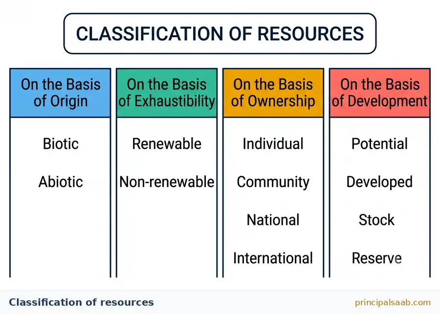
1. On the Basis of Origin: Biotic and Abiotic
This is the easiest one. Ask a single question: was it once alive?
- Biotic resources come from the living world — the biosphere. Forests, crops, fish, livestock, birds and human beings themselves. Even coal and petroleum count as biotic in origin, because they formed from the buried remains of ancient plants and organisms.
- Abiotic resources come from non-living things. Rocks, minerals, metals, water, air, sunlight.
Common Mistake
Students often call coal “abiotic” because it looks like a rock. By origin, coal and petroleum are biotic — they are fossilised remains of living matter. The trap here is that they are also non-renewable by exhaustibility. Two different classifications, two different answers. Do not mix them up.
2. On the Basis of Exhaustibility: Renewable and Non-Renewable
Here the question is: can nature replace it within a human timescale?
- Renewable (replenishable) resources can be renewed or reproduced by physical, chemical or mechanical processes — solar energy, wind energy, water, forests and wildlife. Think of a bank account that receives a salary every month.
- Non-renewable resources take an extremely long geological time to form — often millions of years. Once used up, they are effectively gone for our purposes. Minerals and fossil fuels are the classic examples. Think of a jar of savings with nothing coming in.
There is a subtlety worth knowing, and it impresses examiners. Renewable resources split further into continuous or flow resources (solar and wind energy, which arrive whether we use them or not) and biological resources (forests, fisheries, wildlife, which renew themselves only if we do not destroy the breeding stock). A forest is renewable — but cut every tree and the renewal stops. Renewability is a privilege we can lose.
3. On the Basis of Ownership: Individual, Community, National, International
Now the question is: who has the legal right to use it?
- Individual resources are privately owned by a person — a farmer’s field, a family’s house plot, a well or a borewell inside private land, a plantation or an orchard belonging to one owner.
- Community-owned resources are accessible to all members of a community. Village grazing grounds, village ponds and burial grounds in rural areas; public parks, picnic spots and playgrounds in towns.
- National resources belong to the nation. Legally, all resources within the political boundaries of a country belong to it — land, water, minerals, forests and wildlife. The government can acquire private land for public purposes such as roads, canals or railways. India’s territorial sea extends up to 12 nautical miles from the coast, and everything within it is a national resource.
- International resources are regulated by international institutions. Ocean resources beyond the Exclusive Economic Zone (200 nautical miles from the coast) belong to the international community, and no country may use them without the permission of international bodies.
Exam Tip — Two Numbers Worth Memorising
12 nautical miles = territorial waters (national). 200 nautical miles = Exclusive Economic Zone; beyond it, resources are international. A quick memory hook: 12 like the 12 months you spend at home (national), 200 like a long journey out to open sea (international).
4. On the Basis of Status of Development: Potential, Developed, Stock and Reserve
This is the group students find hardest, so let us take it very slowly with one running story.
- Potential resources — found in a region but not yet used. Rajasthan and Gujarat have enormous potential for solar and wind energy that has still not been fully developed. We know it is there; we have not harnessed it.
- Developed resources — surveyed, their quality and quantity determined, and already being used or ready for use. The determination of usability depends on technology and the level of feasibility.
- Stock — materials in the environment that can satisfy human needs, but we do not yet have the technology to access them. The classic example: water is made of hydrogen and oxygen, and hydrogen is a superb source of energy, but we do not yet have the technical know-how to use it easily on a large scale. So it sits as stock.
- Reserve — a subset of stock that can be used with existing technology, but whose use has not been started yet. It is being kept aside for the future. Water in a dam that can generate hydel power, or forests kept aside for later use, are reserves.
Common Mistake — Stock vs Reserve vs Potential
This trio appears in objective questions almost every year. Fix the difference with one question: do we have the technology?
- Stock — technology is missing. (Hydrogen from water.)
- Reserve — technology exists, use is being saved for later. (Water behind a dam.)
- Potential — the resource exists in a region and is simply not yet developed. (Solar energy in Rajasthan.)
| Basis of Classification | Types | Meaning in One Line | Example |
|---|---|---|---|
| Origin | Biotic | Obtained from the living world | Forests, fisheries, livestock, coal |
| Abiotic | Obtained from non-living things | Rocks, metals, water, air | |
| Exhaustibility | Renewable | Renewed within a human timescale | Solar, wind, water, forests |
| Non-renewable | Takes millions of years to form | Minerals, petroleum, coal | |
| Ownership | Individual | Privately owned by a person | A farmer’s plot, a private orchard |
| Community | Open to all members of a community | Village pond, grazing ground, public park | |
| National | Belongs to the nation; within political boundaries and 12 nautical miles of sea | Minerals, railways, forest land | |
| International | Regulated by international bodies; beyond 200 nautical miles | Open-ocean and deep-sea-bed resources | |
| Status of Development | Potential | Present in a region but not yet used | Solar and wind energy in Rajasthan, Gujarat |
| Developed | Surveyed, quality and quantity known, in use | Coalfields already being mined | |
| Stock | Useful material we lack the technology to use | Hydrogen in water as an energy source | |
| Reserve | Part of stock usable with present technology, saved for future | Water in a dam for hydel power |
Example 3 — Sorting practice (1 mark each)
Question: Classify each of the following under every applicable basis: (i) a village pond, (ii) petroleum, (iii) tidal energy along the Gujarat coast that has not yet been harnessed.
Model answer:
- Village pond — abiotic by origin (water), renewable by exhaustibility, community-owned by ownership, developed by status.
- Petroleum — biotic by origin (formed from ancient organic remains), non-renewable by exhaustibility, national by ownership, developed by status.
- Unharnessed tidal energy — abiotic by origin, renewable by exhaustibility, national by ownership (within territorial waters), potential by status of development.
Why this works: notice how each item gets four labels, not one. If a question says “classify”, always sweep all four bases unless the question restricts you.
Example 4 — Board level (3 marks)
Question: Distinguish between stock and reserve with one example each.
How to structure it: a “distinguish between” question wants a contrast, ideally in two or three matched pairs, not two separate essays. Write it as a small comparison.
Model answer:
- Availability of technology: Stock consists of materials in the environment that could satisfy human needs but which we cannot use because the required technology does not yet exist. A reserve, by contrast, can be used with the technology we already possess.
- Relationship: Reserve is a part of stock; every reserve is stock, but not all stock is a reserve.
- Examples: Hydrogen present in water is a rich potential source of energy but remains stock because we lack easy large-scale technology to use it. Water stored behind a dam that can be used to generate hydroelectricity, but which is being kept for future use, is a reserve.
Marking note: the single sentence “reserve is a subset of stock” is often the difference between 2 and 3 marks. Examiners look for the relationship, not just two definitions.
Example 5 — Application (3 marks)
Question: A coastal fishing village finds that a foreign company is fishing 40 nautical miles off its shore, and another is operating 250 nautical miles out. Explain the ownership position in each case.
Think it through first: the whole question turns on two numbers. Write them down before you answer.
Model answer:
- Waters up to 12 nautical miles from the coast form the territorial sea and everything in them is a national resource belonging entirely to the country.
- The zone up to 200 nautical miles is the Exclusive Economic Zone, within which the coastal nation holds rights over the resources. Fishing at 40 nautical miles therefore falls inside India’s Exclusive Economic Zone and is subject to Indian law and permission.
- Beyond 200 nautical miles, ocean resources are international resources managed by international institutions, so operations at 250 nautical miles fall outside national ownership and are governed by international regulation.
Why it works: the answer converts a story into the two boundary numbers and applies them. Case-study questions almost always reward this “find the rule, then apply it” move.
Development of Resources: Over-Utilisation and Its Consequences
Resources are essential for human survival and for a decent quality of life. But for a long time people assumed something dangerous: that resources are unlimited gifts of nature, and that using more of them always means becoming richer. That assumption led to indiscriminate and irrational use — taking whatever we could, as fast as we could.
Think of it like a student who has been given pocket money for the whole month on day one. Spending freely feels wonderful on day two. By day twenty the problem becomes obvious. Nations have behaved in exactly this way with forests, groundwater, minerals and soil.
Key Idea — Three Major Problems Caused by Over-Utilisation
- Depletion of resources for the satisfaction of the greed of a few individuals.
- Accumulation of resources in a few hands, which divides society into the rich and the poor, or the haves and the have-nots.
- Ecological crises such as global warming, ozone layer depletion, environmental pollution and land degradation.
Sit with the second point for a moment, because students often skip it. Over-use is not only an environmental problem — it is a social problem. When a small group controls most of a resource, everyone else pays the price without receiving the benefit. A village whose groundwater is drawn down by a handful of deep borewells still contains the same amount of land and the same number of people, but the water is now concentrated in a few hands. That is why the chapter insists that resource use must be equitable as well as careful.
Why does this matter for planning? Because if resources were truly unlimited, planning would be pointless — you would simply take what you need. The moment we accept that resources are limited, unevenly spread and capable of being ruined, planning stops being a bureaucratic word and becomes basic survival sense. This is the logical bridge from this section into everything that follows, and examiners love answers that show you understood the bridge.
Example 6 — Board level (5 marks)
Question: “Indiscriminate use of resources has led to numerous problems.” Examine this statement.
How to structure a 5-mark answer: one opening line that accepts the statement, then four to five separate points, each with a short explanation. Never write a 5-mark answer as one unbroken paragraph — split it visually so the examiner can count your points.
Model answer:
Resources were treated for a long time as free and unlimited gifts of nature, and this led to their irrational and indiscriminate use. The consequences have been serious.
- Depletion of resources. Minerals, fossil fuels, groundwater and forests are being consumed far faster than they can be replaced, chiefly to satisfy the greed of a few rather than the needs of all.
- Concentration of resources in few hands. Ownership of land, water and mineral wealth has become concentrated, splitting society into the haves and the have-nots and widening inequality.
- Ecological crises. Excessive burning of fossil fuels and clearing of forests have contributed to global warming, ozone layer depletion and widespread pollution of air and water.
- Land degradation. Over-cultivation, overgrazing, deforestation and mining have stripped fertile topsoil and turned productive land into wasteland.
- Threat to future generations. Resources consumed today are unavailable tomorrow, so unchecked use amounts to borrowing from those who come after us without any intention of repaying.
Marking note: the first three points come straight from the standard list, so they are safe marks. Points 4 and 5 show wider understanding and protect you if the examiner is strict about any single point.
Sustainable Development, the Rio Earth Summit 1992 and Agenda 21
If over-use is the disease, sustainable development is the prescription. The phrase sounds heavy, but the idea is something your grandmother probably practises without naming it: use what you need, keep the source healthy, leave enough for tomorrow.
Key Idea — Sustainable Development
Sustainable economic development means that development should take place without damaging the environment, and development in the present should not compromise the needs of future generations.
Notice the two halves of that sentence. Half one is about the environment — do not wreck the system while growing. Half two is about time — do not steal from the people who come after you. A good answer always contains both halves. Students who write only “development that protects the environment” have written half a definition.
An everyday analogy that always lands: a mango tree in your courtyard. Picking the mangoes each summer is development — you get the fruit. Cutting the tree down for firewood also gets you something today, but there is no fruit ever again. Sustainable development is the discipline of harvesting the mangoes and keeping the tree.
The Rio de Janeiro Earth Summit, 1992
In June 1992, more than a hundred heads of state met at Rio de Janeiro in Brazil for the first International Earth Summit. They had gathered to address urgent problems of environmental protection and socio-economic development at the global level. The leaders signed the Declaration on Global Climatic Change and Biological Diversity. The Summit endorsed the global Forest Principles and adopted Agenda 21 to achieve sustainable development in the twenty-first century.
What Exactly Is Agenda 21?
Agenda 21 is the declaration signed by world leaders at the 1992 United Nations Conference on Environment and Development (UNCED) held at Rio de Janeiro. Its aims are worth learning as three clean points:
- To achieve global sustainable development.
- To combat environmental damage, poverty and disease through global cooperation on common interests, mutual needs and shared responsibilities.
- To encourage every local government to draw its own local Agenda 21.
Exam Tip — The “21” Trap
Agenda 21 is not a list of twenty-one points, and it is not named after twenty-one countries. The 21 refers to the twenty-first century — it is an agenda for the 21st century, adopted in 1992. Students lose easy objective marks on this every year.
The third aim — every local government drawing its own local Agenda 21 — is the most practical part and the one most worth understanding. A global promise means nothing if a municipality still dumps untreated sewage into its river. So the Summit deliberately pushed responsibility downwards: your city, your ward, your school can each have a plan.
Example 7 — Board level (3 marks)
Question: What is Agenda 21? State any two of its objectives.
How to structure it: the question has two parts, so give it two parts. One mark for identifying what Agenda 21 is, one mark for each objective.
Model answer:
Agenda 21 is the declaration adopted by world leaders at the United Nations Conference on Environment and Development held at Rio de Janeiro in 1992. It is a blueprint for achieving sustainable development in the twenty-first century.
Its objectives include:
- Combating environmental damage, poverty and disease through global cooperation based on common interests, mutual needs and shared responsibilities.
- Encouraging every local government to prepare its own local Agenda 21, so that sustainability is pursued at the local as well as the global level.
Marking note: mentioning the year (1992) and the place (Rio de Janeiro) makes the first mark unambiguous. Dates and places are cheap marks — never leave them out.
Resource Planning in India: The Three-Stage Process
Resource planning is simply the widely accepted strategy for the judicious use of resources. In a country like India it is not optional, and the reason is one word: unevenness.
India’s resources are distributed very unevenly across the country. Some regions are rich in certain kinds of resources and desperately short of others. Learn these four contrasts — they are the standard illustrations and they answer half the questions in this section.
- Jharkhand, Chhattisgarh and Madhya Pradesh are rich in minerals and coal deposits.
- Arunachal Pradesh has abundant water resources but lacks infrastructure development.
- Rajasthan is very well endowed with solar and wind energy but lacks water resources.
- Ladakh has a rich cultural heritage but is deficient in water, important minerals and infrastructure.
Sit with that Rajasthan line for a second, because it is the perfect example of a planning-versus-endowment mismatch. Rajasthan receives some of the most generous sunshine in the country — an energy fortune lying in the open. What it does not have is water. So a plan that ignores endowment and simply says “grow more water-intensive crops in Rajasthan” is a plan that fights geography and loses. A plan that says “harness the sun, and manage water with extreme care” works with the endowment. Good planning is not about wanting more; it is about matching what you do to what you have.
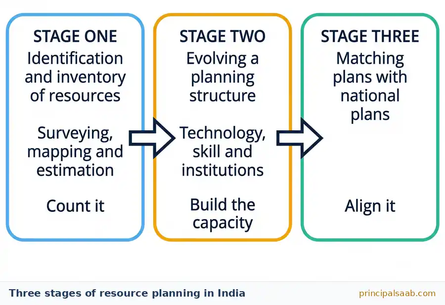
Key Rule — The Three Stages of Resource Planning in India
- Identification and inventory of resources across the regions of the country. This involves surveying, mapping, and qualitative and quantitative estimation and measurement of the resources.
- Evolving a planning structure endowed with appropriate technology, skill and institutional set-up for implementing resource development plans.
- Matching the resource development plans with overall national development plans.
Why does it work in this order? Because you cannot plan for what you have not counted. Stage one is the survey — knowing what and how much. Stage two is building the machinery — technology, trained people and institutions that can actually do something with the survey. Stage three prevents a very common failure: a brilliant local plan that pulls against national priorities. Think of it as: count it, build the capacity, then align it. If you can say those six words in the exam hall you can rebuild the whole answer.
Common Mistake
Many students write the three stages but forget stage one includes both surveying/mapping and qualitative and quantitative estimation. Simply writing “identify resources” is thin. Also, do not confuse resource planning with resource conservation — planning is about judicious use and organisation; conservation is about protecting and saving. Questions on the two are worded very similarly.
One more caution the chapter is careful to make, and it is genuinely important. Having plenty of resources is not by itself enough for development. History shows colonies that were rich in resources and yet remained poor, because the colonising powers had the technology, the institutions and the political control. Meanwhile some countries with relatively few natural resources became highly developed. Development requires resources and technology and the quality of human resources and institutions.
Example 8 — Board level (5 marks)
Question: Why is resource planning essential in a country like India? Explain the stages involved in it.
How to structure it: the question has two clear halves. Give roughly two marks to “why” and three to “stages”. Use a sub-heading for each half so the examiner sees the split instantly.
Model answer:
Why it is essential:
- Resources in India are unevenly distributed. Jharkhand and Chhattisgarh are rich in minerals and coal, Rajasthan is rich in solar and wind energy but poor in water, Arunachal Pradesh has abundant water but weak infrastructure, and Ladakh is rich in culture but deficient in water and minerals.
- Resources are limited and exhaustible, so unplanned use leads to depletion, inequality and ecological damage. Planning ensures judicious use.
Stages of resource planning:
- Identification and inventory of resources region by region, through surveying, mapping and qualitative and quantitative estimation.
- Evolving a planning structure equipped with suitable technology, skills and institutions to implement the plans.
- Matching resource development plans with the overall national development plans so that local and national priorities move together.
Marking note: the regional examples in the “why” half are what lift this from an average answer to a full-marks answer. Two named states are enough; four is generous.
Example 9 — Case application (3 marks)
Question: A state has large coal deposits but very little surface water and few trained engineers. A committee proposes setting up several heavy industries immediately. Using your understanding of resource planning, evaluate this proposal.
Think it through first: the state clearly has an endowment (coal) but the question is deliberately telling you two things are missing — water and skilled people. That maps directly onto stage two of resource planning.
Model answer:
- The proposal correctly recognises the state’s mineral endowment, which satisfies the first stage of planning — the resources have been identified.
- However, it ignores the second stage. A planning structure with appropriate technology, skill and institutional support must exist before development plans can succeed; here, trained personnel are lacking and water, essential for heavy industry, is scarce.
- The proposal should therefore be revised to first build technical training capacity and secure a reliable water supply, and to align the industrial plan with national development priorities, rather than beginning construction immediately.
Why it works: the answer names the stage that is being skipped instead of just saying “the plan is bad”. Naming the concept is what earns the mark in an application question.
Conservation of Resources: Gandhi, the Club of Rome and Brundtland
Resources are vital for any developmental activity. But using them irrationally creates serious socio-economic and environmental problems. Conservation is the answer — the careful, planned use of resources so that they last and so that everybody gets a fair share.
This section names some thinkers and reports. Do not panic about the names — there are only a handful and they fall into two neat strands.
Strand One: The Gandhian View
Mahatma Gandhi expressed his concern about resource conservation in these terms: there is enough for everybody’s need but not for anybody’s greed. He placed the blame for resource depletion at the global level on greedy and selfish individuals and on exploitative modern technology. He was against mass production and wanted to replace it with production by the masses.
That last phrase deserves a moment. “Mass production” means a small number of large factories making enormous quantities using heavy machinery. “Production by the masses” means large numbers of ordinary people each producing on a small scale, using simple technology and local materials. Gandhi’s argument was that the second model spreads both the benefit and the environmental load more thinly, instead of concentrating wealth in a few hands and damage in a few places.
Exam Tip
“Mass production” versus “production by the masses” is a favourite one-mark distinction. Remember the direction: Gandhi wanted the masses producing, not the masses consuming what a few produce.
Strand Two: The Club of Rome and Brundtland Line of Thinking
The second strand is the international, report-writing strand. Learn it as a timeline — timelines are far easier to remember than loose facts.
| Year | Milestone | What It Contributed |
|---|---|---|
| 1968 | Club of Rome advocated resource conservation | First major global platform to argue that resource use must be limited; a new context for conservation |
| 1974 | Gandhian philosophy presented by Schumacher in Small is Beautiful | Carried Gandhi’s ideas about scale, simplicity and appropriate technology to a worldwide audience |
| 1987 | Brundtland Commission Report, Our Common Future | Introduced the concept of sustainable development and advocated it as a means for resource conservation |
| 1992 | Rio de Janeiro Earth Summit | Adopted Agenda 21 and endorsed global Forest Principles; brought conservation into world policy |
A memory hook that works for almost everyone: 68 → 74 → 87 → 92. Club of Rome sounds the alarm, Schumacher offers the philosophy, Brundtland names the solution, Rio turns it into policy. Four steps: alarm, philosophy, name, policy.
Common Mistake
Do not credit the Rio Summit with inventing sustainable development. The concept was introduced in the Brundtland Commission Report (1987). Rio (1992) adopted and operationalised it through Agenda 21. Getting the order right is worth an easy mark.
Example 10 — Board level (3 marks)
Question: Describe Gandhiji’s views on conservation of resources.
How to structure it: three points — the famous statement, whom he blamed, and what he proposed instead. Do not simply repeat the quotation three times in different words.
Model answer:
- Gandhiji held that nature provides enough to satisfy everybody’s need but not enough for anybody’s greed, so scarcity arises from human greed rather than from nature’s limits.
- He blamed the depletion of resources at the global level on greedy and selfish individuals and exploitative modern technology, which extract far more than is required.
- He opposed mass production and favoured production by the masses, that is, small-scale production by large numbers of people using simple technology, which spreads benefits widely and puts less strain on the environment.
Marking note: the need-versus-greed contrast is expected, but points 2 and 3 are where most students stop short. All three together make a complete three-mark answer.
Land Resources and India’s Relief: Mountains, Plains and Plateaus
We now come down to earth — literally. Land is a natural resource of utmost importance. It supports natural vegetation, wildlife, human life, economic activities, transport and communication systems. Land is an asset of a finite magnitude — which is simply a formal way of saying they are not making any more of it. That single fact is why every argument about land use is an argument about trade-offs.
India has land under a great variety of relief features: plains, plateaus, mountains, islands and deserts. Here is the standard breakdown that you should know cold.
Key Idea — India’s Relief in Three Numbers
- About 43 per cent of the land area is plain, which provides facilities for agriculture and industry.
- About 30 per cent of the total surface area is mountainous, which ensures perennial flow of some rivers, provides facilities for tourism and ecological aspects.
- About 27 per cent of the area of the country is plateau, which possesses rich reserves of minerals, fossil fuels and forests.
Do you see how neatly the three numbers add to 100? That is your check in the exam hall: 43 + 30 + 27 = 100. If your recalled numbers do not add to a hundred, one of them is wrong.
But the numbers are only half the point. Notice that each relief type brings its own kind of usefulness. Plains are flat and fertile, so we farm and build cities on them. Mountains are steep and cold — poor for farming, but they hold the snow that feeds perennial rivers, they draw tourists and they shelter fragile ecosystems. Plateaus are hard old rock — poor for the plough in many places, but that same old rock is exactly where minerals and coal are found. India is not “43 per cent good land and 57 per cent leftover”. It is three different kinds of usefulness.
Good to Know
This relief pattern quietly explains most of the rest of the chapter. Plateaus made of old crystalline rock give red soil and, where lava flowed, black soil. Plains built by rivers give alluvial soil. Mountains give forest soil. If you understand relief, the soil map almost draws itself.
Example 11 — Board level (3 marks)
Question: “India has a variety of relief features, and each is useful in a different way.” Explain with reference to plains, mountains and plateaus.
How to structure it: one mark per relief feature. Give the approximate share and the specific usefulness for each — the share alone is not an explanation.
Model answer:
- Plains cover about 43 per cent of the land area. Being level and fertile, they provide favourable conditions for agriculture, industry and the building of transport networks and settlements.
- Mountains account for about 30 per cent of the surface area. They store snow that ensures the perennial flow of rivers, support tourism, and perform important ecological functions.
- Plateaus cover about 27 per cent of the area. Formed of ancient rock, they hold rich reserves of minerals, fossil fuels and forests.
Marking note: a strong closing line such as “thus the variety of relief supports a wide range of economic activities” costs one sentence and often secures the final mark on “explain” questions.
Land Utilisation Categories and Net vs Gross Cropped Area
Government records divide the land of India into a fixed set of categories. This looks like a boring list, and I will not pretend otherwise — but it is a list that repays five minutes of honest attention, because questions from here are short, predictable and fully within your control.
Land resources are divided broadly under the following heads.
| Category | What It Means, in Plain Words | Everyday Example |
|---|---|---|
| Forests | Land officially recorded and designated as forest area | A reserved forest block near a hill town |
| Barren and waste land | Land that cannot be brought under cultivation with available technology | Rocky hill slopes, sandy desert, ravines, glaciers |
| Land put to non-agricultural uses | Land occupied by settlements, roads, railways, industry and so on | A town, a highway, a factory estate |
| Permanent pastures and grazing land | Land kept aside for livestock to graze | Village common grazing ground |
| Land under miscellaneous tree crops and groves | Tree crops and groves that are not counted in the net sown area | A mango grove or bamboo clump at the village edge |
| Culturable waste land | Land left uncultivated for more than five agricultural years, but which could be cultivated | An abandoned field choked with weeds and salt crust |
| Current fallow | Land left without cultivation for one or less than one agricultural year | A field rested for a single season to recover fertility |
| Other than current fallow | Land left uncultivated for one to five agricultural years | A field lying idle for three years while the owner works elsewhere |
| Net sown area | The area actually sown with crops, counted once however many times it is cropped | The cultivated fields of a village, measured on the ground |
Now let us slow right down on the three “fallow-ish” categories, because they are the single most confusing part of this list and the most examined.
Key Rule — The Fallow Ladder (learn it as a timeline)
- Up to one year uncultivated → Current fallow
- One to five years uncultivated → Other than current fallow
- More than five years uncultivated, but still cultivable → Culturable waste land
- Cannot be cultivated at all → Barren and waste land
Picture a single field and walk it up the ladder. Year one it rests — current fallow. Years two to five it still lies idle — other than current fallow. Cross five years and it slips into culturable waste. It is the same piece of earth the whole time; only the duration changed. That is the entire trick.
Common Mistake — Culturable Waste vs Barren Waste
The word “waste” appears in both, and students merge them. The difference is capability, not appearance. Culturable waste can be cultivated if effort is put in — it is idle, not hopeless. Barren and waste land cannot be cultivated with available technology — deserts, rocky slopes, ravines, glaciers. Memory hook: culturable = curable.
Net Sown Area vs Gross Cropped Area
This one pair of terms is worth its own sub-heading because it is asked again and again, and because the idea behind it is genuinely elegant.
- Net sown area is the physical area actually sown with crops. Each field is counted once, no matter how many crops it grows in a year.
- Gross cropped area is the net sown area plus the area sown more than once in the same agricultural year. Each field is counted as many times as it is cropped.
Here is the analogy that makes it click. Imagine a cricket ground used for three matches in one season. The ground is one — that is the net sown area. The matches are three — that is closer to the gross cropped area. Net counts the land; gross counts the use of the land.
Why does the difference matter? Because it tells you about cropping intensity. If a district has a small net sown area but a large gross cropped area, its farmers are growing two or three crops on the same field each year — which usually means dependable irrigation, good soil and short-duration varieties. Two districts can have identical net sown areas and completely different agricultural output. Land quantity is not the same as land productivity.
Common Mistake — Net vs Gross
Gross cropped area is always equal to or greater than net sown area — never smaller. If you ever write an answer in which gross is less than net, you have made an error somewhere. Also remember: gross cropped area can exceed the total land area of a district without anything being wrong, because the same field is counted more than once.
Example 12 — Warm-up (1 mark each)
Question: Name the land-use category for each: (i) a field left uncultivated for four years, (ii) a stretch of sand dunes in the Thar Desert, (iii) a plot lying idle for eight years but which could be revived with levelling and irrigation.
Model answer:
- (i) Fallow other than current fallow — the gap is between one and five years.
- (ii) Barren and waste land — sand dunes cannot be cultivated with available technology.
- (iii) Culturable waste land — uncultivated for more than five years, but capable of cultivation.
Why it works: each answer names the deciding feature (duration, or capability). In one-mark questions the name alone is enough, but adding the reason costs three words and protects you if the examiner wants justification.
Example 13 — Application (3 marks)
Question: Village A and Village B each have a net sown area of 200 hectares. Village A’s gross cropped area is 210 hectares; Village B’s is 380 hectares. What does this tell you, and why might the difference exist?
Think it through first: both villages farm the same amount of land. The difference is in how many times that land is cropped.
Model answer:
- Both villages have the same net sown area, meaning the physical extent of cultivated land is identical at 200 hectares.
- Village B has a much higher gross cropped area, which shows that a large part of its land is sown more than once in the same agricultural year. Its cropping intensity is far higher than Village A’s.
- The likely reasons are better assured irrigation, more fertile soil, and the use of short-duration or high-yielding varieties that allow two or three crops per year, whereas Village A probably depends largely on rainfall and can manage only a single crop.
Marking note: the phrase “sown more than once in the same agricultural year” is the technical definition and should appear word-for-word in your answer. Examiners scan for it.
The Land Use Pattern in India and Why It Keeps Changing
How a country actually uses its land is decided by two sets of forces working together.
- Physical factors — the topography, climate and soil types of the place. You cannot plough a glacier.
- Human factors — population density, technological capability, culture and traditions. A society decides what to do with what physical nature allows.
Good to Know — Why the Total Never Quite Adds Up
Land-use statistics in India are reported for roughly 93 per cent of the total geographical area, not 100 per cent. Reporting is incomplete for some north-eastern states except Assam, and figures are not available for areas occupied by neighbouring countries. So if a data table you are given does not sum to India’s full area, that is expected, not a printing error.
The Broad Picture (with figures you can quote safely)
Please read the next paragraph carefully, because figures in this section differ between textbook editions and between government reports. I am giving you the source and the year for each one. In an exam, quoting an approximate figure with its source and year is far safer than quoting a precise-sounding figure with no source at all.
- Net sown area: according to the Ministry of Agriculture’s Land Use Statistics at a Glance, 2022-23, India’s net sown area is roughly 140 million hectares, which works out to a little under half — broadly 45 to 47 per cent — of the reporting area. The share varies enormously between states: it is very high in Punjab and Haryana and very low in hilly and forested states such as Arunachal Pradesh and Mizoram.
- Forest area (land-use records): land officially recorded as forest in the same 2022-23 statistics is roughly 71 million hectares, or a little over 23 per cent of the reporting area.
- Actual forest cover (satellite-assessed): the India State of Forest Report 2023, published by the Forest Survey of India, puts India’s forest cover at 21.76 per cent of the geographical area, with forest and tree cover together at 25.17 per cent.
- Permanent pastures occupy only a small share — of the order of 3 per cent — and have been shrinking, which is one reason grazing pressure on other land has grown so heavy.
Common Mistake — Two Different Forest Numbers
Students see “23 per cent” in one place and “21.76 per cent” in another and assume one is wrong. Both are correct — they measure different things. Recorded forest area is a legal and administrative category in revenue records. Forest cover is what satellites actually see growing on the ground, regardless of legal status. If a question asks about land-use categories, use the land-use figure; if it asks about actual forest cover, quote the Forest Survey of India figure and name the report.
Whichever figure you use, both fall well short of the 33 per cent of geographical area recommended by the National Forest Policy of 1952 for maintaining ecological balance. That gap — roughly a third recommended against roughly a fifth to a quarter achieved — is the single most quotable fact in this whole section.
Why the Pattern Keeps Shifting
Land use in India is not a frozen photograph; it is a slow-moving film. Three shifts matter.
- Land under non-agricultural uses is rising steadily. Towns spread, highways are built, industrial estates come up. Almost every hectare gained here is lost from farmland or grazing land, and the change is effectively permanent — nobody un-builds a city.
- Grazing land is declining. Pressure on village commons has pushed pastures down to a small fraction of the total, while cattle numbers have not fallen correspondingly. The result is severe overgrazing on whatever grazing land remains.
- Net sown area has been broadly stable or has fallen slightly, while gross cropped area has grown. In other words, India is not adding much new farmland; it is working the existing farmland harder through multiple cropping. This is impressive, but it also puts continuous strain on soil nutrients and groundwater.
Read that last point once more, because it is the quiet warning of the whole chapter. A country that stops expanding its farmland but keeps increasing its harvests is squeezing more from the same soil every year. That is exactly the condition under which land degradation accelerates — which is precisely where we go next.
Example 14 — Board level (5 marks)
Question: Explain the factors that determine the land use pattern of a country, and describe any three changes visible in India’s land use pattern.
How to structure it: two marks for factors, three for changes. Announce the two halves with a short phrase each — examiners mark faster and more generously when the structure is visible.
Model answer:
Factors determining land use:
- Physical factors such as topography, climate and soil type set the outer limits of what land can be used for; steep, cold or rocky land cannot be cultivated however much we may wish it.
- Human factors such as population density, technological capability, culture and tradition decide which of the physically possible uses a society actually adopts.
Changes visible in India:
- Land under non-agricultural uses has increased because of the expansion of settlements, roads, railways and industry, and this land is rarely returned to farming.
- Permanent pastures and grazing land have declined to a small share of the reporting area, while livestock numbers have not fallen proportionately, causing severe overgrazing.
- Net sown area has remained broadly stable while gross cropped area has risen, showing that India now depends on multiple cropping of existing fields rather than on new farmland, which increases pressure on soil fertility and groundwater.
Marking note: a five-mark answer needs five identifiable ideas. Counting your own numbered points before you move on is a two-second habit that saves marks.
Land Degradation and Conservation Measures
We have just seen that India is working the same land harder every year. When land is used continuously over thousands of years without care, its quality falls. That fall in quality is land degradation, and it is one of the most serious quiet crises the country faces.
Key Idea — The Scale of the Problem
According to the Desertification and Land Degradation Atlas of India published in 2021 by the Space Applications Centre (ISRO), about 97.85 million hectares of India’s land underwent degradation in 2018-19 — close to 30 per cent of the country’s total geographical area. The share has been creeping upwards across successive assessments, from roughly 28.8 per cent in 2003-05 to about 29.3 per cent in 2011-13.
Let that settle. Roughly three hectares in every ten across the country are degrading. This is not a distant environmental worry; it is arithmetic about the food on our plates.
Human Causes, Region by Region
Some degradation is natural, but human activities have made it far worse. The examinable part is the region-to-cause matching, so learn it as pairs.
| Human Activity | Regions Worst Affected | How It Damages the Land |
|---|---|---|
| Deforestation and mining | Jharkhand, Chhattisgarh, Madhya Pradesh, Odisha | Trees are cleared and deep pits are dug; mining debris and dust are left behind, and abandoned pits become wasteland |
| Overgrazing | Gujarat, Rajasthan, Madhya Pradesh, Maharashtra | Animals strip vegetation faster than it regrows, leaving bare soil that wind and rain carry away |
| Over-irrigation and waterlogging | Punjab, Haryana, western Uttar Pradesh | Excess water raises the water table and brings salts to the surface; salinity and alkalinity make land infertile |
| Mineral processing (cement, ceramic, soapstone, quartzite grinding) | Industrial belts across several states | Fine dust settles on the land, blocks soil pores, retards water infiltration and smothers crops |
| Untreated industrial effluents | Industrial towns nationwide | Chemical waste flows onto land and into groundwater, poisoning soil and reducing fertility |
Exam Tip — A Three-Word Memory Hook
Remember MOW-D: Mining (Jharkhand, Chhattisgarh, Odisha, MP), Overgrazing (Gujarat, Rajasthan, MP, Maharashtra), Waterlogging from over-irrigation (Punjab, Haryana, western UP), Dust and effluents from industry. Four causes, four regions, one word.
Conservation Measures — the Fixes, and Why Each One Works
Do not learn these as a list. Learn each one with a picture and a reason, and you will never forget them.
- Afforestation and proper management of grazing land. Roots bind soil and leaves break the force of falling rain. Controlling how many animals graze where, and for how long, lets grass recover. Why it works: vegetation is nature’s own soil-holding net.
- Planting of shelter belts. Rows of trees planted across the direction of the prevailing wind, especially in dry western India. Why it works: they slow the wind near the ground, so it no longer has the energy to lift and carry away loose soil. Shelter belts have contributed significantly to stabilising sand dunes and stabilising deserts in western India.
- Control of overgrazing. Rotational grazing, stall feeding and limits on herd size. Why it works: it gives grass a chance to regrow between grazings, so the soil is never left bare.
- Stabilisation of sand dunes by growing thorny bushes. Why it works: thorny shrubs survive in very dry conditions and their root networks physically pin down shifting sand.
- Contour ploughing. Ploughing along the contour lines of a slope rather than up and down it. Why it works: each furrow becomes a tiny horizontal ridge that catches running water instead of channelling it downhill. Ploughing up and down a slope is effectively building drainage channels for your own topsoil.
- Terrace farming. Cutting a hillside into a staircase of flat steps, as in the western and central Himalayas. Why it works: it converts one long steep slope into many short flat ones, so water walks down instead of running down.
- Strip cropping. Alternating strips of crops with strips of grass or a different crop across a field. Why it works: the grass strips act as brakes, breaking up the force of the wind and slowing water flowing across the surface.
- Proper management of waste lands and reclamation of mine-spoiled land. Refilling pits, spreading stored topsoil and replanting. Why it works: it restores both the physical shape of the land and the biological layer that makes it productive.
- Control of mining activities and treatment of industrial effluents. Regulating where and how mining occurs, and treating waste water before discharge. Why it works: it stops the damage at the source rather than trying to repair it afterwards, which is always cheaper.
Key Idea — The One Principle Behind All Nine Measures
Every single conservation measure does one of two things: it either slows the moving agent (wind or water) or it holds the soil in place (roots, terraces, ridges). If you forget a specific method in the exam, reason from this principle and you will usually reconstruct it correctly.
Example 15 — Board level (5 marks)
Question: Explain any five human activities responsible for land degradation in India, mentioning the regions affected.
How to structure it: five points, each in the format activity → region → damage caused. Naming the region is what separates a full answer from a half answer here.
Model answer:
- Deforestation and mining in states such as Jharkhand, Chhattisgarh, Madhya Pradesh and Odisha strip away vegetation and leave deep pits and debris, converting productive land into wasteland.
- Overgrazing in Gujarat, Rajasthan, Madhya Pradesh and Maharashtra removes the protective grass cover faster than it can regrow, exposing bare soil to wind and rain.
- Over-irrigation in Punjab, Haryana and western Uttar Pradesh raises the water table and causes waterlogging, which increases salinity and alkalinity of the soil and reduces its fertility.
- Mineral processing industries such as cement, ceramic, soapstone and quartzite grinding release large quantities of dust that settle on the land, block soil pores and slow water infiltration.
- Discharge of untreated industrial effluents in industrial areas pollutes both the soil and groundwater with chemical waste, making the land progressively less productive.
Marking note: if you are short of time, write the activity and region first for all five, then add the damage. Partial points across five items score better than three perfect items and two blanks.
Example 16 — Case application (5 marks)
Question: A hilly village reports that every monsoon its topsoil washes into the stream below, and its slopes are now scarred with narrow channels. Suggest four conservation measures suited to this village and explain how each would help.
Think it through first: the key words are hilly, monsoon and channels. That means running water on a slope. So the answer must choose water-and-slope measures, not wind measures. Choosing shelter belts here would be a mismatch and would lose marks.
Model answer:
- Contour ploughing — ploughing along the contours of the slope creates ridges that trap running water instead of guiding it downhill, so less soil is carried away.
- Terrace farming — cutting the slope into flat steps, as practised in the western and central Himalayas, reduces one long steep slope into several short level ones and greatly slows the movement of water.
- Strip cropping — alternating strips of crops with strips of grass across the slope breaks the flow of water and acts as a brake on soil movement.
- Afforestation on the upper slopes — tree roots bind the soil and the canopy softens the impact of heavy monsoon rain, preventing the channels from deepening further into gullies.
Why it works: every measure chosen is matched to the actual agent of erosion described in the question. In a case study, the examiner is testing whether you can pick the right tool, not whether you can list every tool.
Soil as a Resource: How Soil Is Formed
We now arrive at the heart of the chapter. Take this section slowly — if you understand how soil forms, you will not have to memorise the soil types at all. They will follow logically.
Key Idea — What Soil Is
Soil is the most important renewable natural resource. It is the medium of plant growth and supports different types of living organisms on the earth. It is a living system, and it takes millions of years to form soil up to a few centimetres in depth.
Please pause on that last sentence, because it changes how you think about everything that follows. A few centimetres of soil represent millions of years of work. A single bad monsoon on a bare hillside can strip that away in one season. Soil is technically renewable, but on a timescale so slow that for practical human purposes, losing it is losing it forever. This is exactly why soil conservation matters so intensely.
How Soil Forms
Various forces of nature — changes in temperature, actions of running water, wind and glaciers, and activities of decomposers — contribute to the formation of soil. Chemical and organic changes which take place in the soil are equally important. Soil consists of organic (humus) and inorganic materials.
Think of it as a two-part recipe:
- The mineral part comes from rock, broken down over ages. Heat expands rock, cold contracts it, water seeps into cracks and freezes, wind grinds and rivers tumble — over long periods, solid rock becomes fine particles.
- The organic part (humus) comes from dead plants and animals, broken down by bacteria, fungi, earthworms and other decomposers into a dark, spongy material.
Rock particles alone are just sand — they hold no water and feed nothing. Humus alone would wash away. Together they make soil: a material that holds water like a sponge, holds nutrients, and lets roots breathe. That combination is what makes agriculture possible on this planet.
The Factors That Shape Soil
Five factors decide what kind of soil forms in a given place. Learn them with the reason attached.
- Relief (the shape of the land). On steep slopes soil is washed away as fast as it forms, so it stays thin; in flat valleys and plains it accumulates and becomes deep.
- Parent rock or bedrock. The rock beneath supplies the mineral matter, so it decides colour, texture and mineral content. Volcanic lava gives dark, clayey soil; ancient crystalline rock gives reddish, sandy soil.
- Climate. Temperature and rainfall control how fast rock breaks down and how fast organic matter decomposes. Heavy rain washes nutrients downward; dry heat leaves salts near the surface.
- Vegetation and other forms of life. Plants add organic matter, roots hold particles, and soil organisms mix and enrich the whole thing.
- Time. Everything above needs enormous stretches of time to act. Time is why soil formation is measured in millions of years.
Exam Tip — A Memory Hook for the Five Factors
Think of R-P-C-V-T: Relief, Parent rock, Climate, Vegetation, Time. Or read it as a sentence: “Really Pretty Countryside Vegetates over Time.” Silly sentences survive exam nerves far better than lists.
Here is why understanding these five factors is such a good investment. Every soil type you are about to meet is simply a different combination of them. Black soil? Volcanic parent rock plus a semi-arid climate. Laterite soil? Heavy rain plus high temperature washing everything soluble away. Alluvial soil? Rivers depositing material on flat plains. You are not memorising six unrelated things; you are applying one framework six times.
Example 17 — Board level (3 marks)
Question: Why is soil described as a living system, and why is its conservation so urgent? Explain.
How to structure it: two ideas about “living system”, one about urgency. Keep the timescale point for last — it is the strongest note to end on.
Model answer:
- Soil is not merely crushed rock. It contains organic matter or humus formed from decayed plants and animals, along with inorganic mineral material, so it is a mixture of the living and the non-living.
- It supports a vast range of living organisms — bacteria, fungi, earthworms and plant roots — whose activity continually renews and enriches it, which is why it is called a living system.
- Its conservation is urgent because it takes millions of years for soil to form even to a depth of a few centimetres, whereas careless use can destroy it within a few seasons; for practical purposes the loss is irreversible.
Marking note: the words “humus”, “living organisms” and “millions of years” are the three scoring anchors. Everything else is packaging.
Classification of Soils in India: The Six Major Types
India has an enormous variety of relief, landforms, climate and vegetation, and so it has an enormous variety of soils. On the basis of factors such as texture, colour, age and chemical and physical properties, India’s soils are classified into these major types. Take them one at a time. I recommend three today and three tomorrow.
1. Alluvial Soil
This is the most widespread and the most important soil in India. The entire northern plains are made of alluvial soil, deposited by three great Himalayan river systems — the Indus, the Ganga and the Brahmaputra. It extends into Rajasthan and Gujarat through a narrow corridor, and is also found in the eastern coastal plains, particularly in the deltas of the Mahanadi, the Godavari, the Krishna and the Kaveri.
- How it forms: rivers carry fine sediment down from the mountains and drop it where their speed falls, on flat plains and in deltas. It is a transported soil — made elsewhere, delivered here.
- Texture: varies from sandy loam to clay. As a rule, the particles get finer as you move away from the mountains, because the river drops its heaviest load first. Upper river valleys have coarser, pebbly soil; the middle and lower Ganga plain and the Brahmaputra valley have finer soil.
- Nutrients: generally very fertile, rich in potash, phosphoric acid and lime.
- Crops: ideal for sugarcane, paddy, wheat and other cereal and pulse crops.
- Why it matters: regions of alluvial soil are intensively cultivated, densely populated and agriculturally the most productive in the country.
Now the sub-division you must know: khadar and bangar. According to their age, alluvial soils are classified as old alluvial (bangar) and new alluvial (khadar).
| Feature | Khadar (new alluvial) | Bangar (old alluvial) |
|---|---|---|
| Age | New, renewed almost every year | Old |
| Location | Low-lying land close to the river, in the flood plain | Higher ground away from the river, above flood level |
| Texture | Finer particles | Coarser; often contains kankar, that is, calcareous or lime nodules |
| Fertility | More fertile, because floods deposit fresh silt each year | Less fertile than khadar |
| Farming value | Ideal for intensive cultivation | Cultivable, but yields are generally lower |
Common Mistake — Khadar vs Bangar
Students swap these two constantly. Use this hook and you will never confuse them again:
Khadar = Kai naya (new), found Kinare (near the bank), gets a fresh Kambal of silt every flood. Bangar is the “buzurg” or elder — older, higher up, drier, with lime kankar nodules in it. And remember: kankar goes with bangar — both have that hard, old feel to the word.
2. Black Soil (Regur Soil)
These soils are black in colour and are also known as regur soils. They are ideal for growing cotton, and are therefore also called black cotton soil.
- Where: the Deccan trap region, spread over the plateaus of Maharashtra, Saurashtra, Malwa, Madhya Pradesh and Chhattisgarh, and extending in the south-east along the Godavari and the Krishna valleys.
- How it forms: climatic conditions along with the parent rock material are the important factors. It develops on lava flows — the ancient volcanic rock of the Deccan trap — under a hot, relatively dry climate.
- Texture and properties: made of extremely fine, clayey material. It is well known for its capacity to hold moisture.
- Nutrients: rich in soil nutrients such as calcium carbonate, magnesium, potash and lime. It is generally poor in phosphoric contents.
- Crops: cotton above all, and also suited to jowar, wheat, linseed, sunflower and pulses.
Now the famous behaviour that examiners love. These soils develop deep cracks during hot weather, which helps in the proper aeration of the soil. They are also sticky when wet and difficult to work with unless tilled immediately after the first shower or during the pre-monsoon period.
Key Idea — Why Black Soil Cracks, and Why That Is Useful
Black soil is made of very fine clay. Clay swells when wet and shrinks when dry. In the fierce heat of the Deccan summer the soil dries deeply and shrinks, opening wide cracks. Those cracks let air deep into the soil — which is self-aeration, a free service that most soils need ploughing to achieve. The same fineness that causes the cracking is also what lets black soil hold moisture so well, which is exactly why cotton, a long-duration crop, thrives on it even where rainfall is modest.
Do you see how one property — extreme fineness — explains the colour-independent behaviour, the moisture retention, the cracking and the stickiness? Understand the fineness and you have understood black soil.
3. Red and Yellow Soil
- Where: areas of low rainfall in the eastern and southern parts of the Deccan plateau. It is also found in parts of Odisha, Chhattisgarh, the southern parts of the middle Ganga plain and along the piedmont zone of the Western Ghats.
- How it forms: it develops on crystalline igneous rocks in areas of low rainfall.
- Why the colour: the soil looks reddish because of the diffusion of iron in crystalline and metamorphic rocks. It appears yellow when it occurs in a hydrated form — that is, when the iron compounds have absorbed water.
- Fertility: generally less fertile than alluvial or black soil; it responds well to fertilisers and irrigation.
- Crops: with proper inputs it supports millets, groundnut, pulses, potato and rice in the wetter parts.
Common Mistake — Black Soil vs Red Soil on the Deccan
Both occur on the Deccan plateau, and students mix them up. Separate them by parent rock and rainfall. Black soil forms on lava flows (the Deccan trap of the north-west Deccan — Maharashtra, Malwa, Saurashtra). Red soil forms on old crystalline and metamorphic rock in the eastern and southern Deccan, in areas of low rainfall. Different rock underneath, different soil on top. Also note: the red colour comes from iron, not from the soil being infertile — colour and fertility are unrelated questions.
4. Laterite Soil
The name comes from the Latin word later, meaning brick — and that tells you almost everything about it.
- Where: found in Karnataka, Kerala, Tamil Nadu, Madhya Pradesh, and the hilly areas of Odisha and Assam.
- How it forms: it develops under conditions of high temperature and heavy rainfall. It is the result of intense leaching due to heavy rain.
- Properties: humus content is low, because most of the micro-organisms, particularly the decomposers such as bacteria, are destroyed by the high temperature. The soil is therefore generally not very fertile in its natural state.
- Crops and uses: after adopting adequate soil conservation techniques, laterite soil is useful for growing tea and coffee. Red laterite soils in Tamil Nadu, Andhra Pradesh and Kerala are more suitable for tree crops like cashew nut. It is also widely used as building material, cut into blocks.
What on earth is leaching? Here is the everyday picture. Imagine pouring water repeatedly through a jar of tea leaves. After many rinses, everything that could dissolve has washed out and only the tough, insoluble residue remains. Heavy tropical rain does exactly this to soil over centuries: it dissolves and carries away the soluble nutrients, leaving behind mainly the insoluble compounds of iron and aluminium. That is why laterite is nutrient-poor despite forming in a lush, high-rainfall region — a lovely paradox that examiners enjoy testing.
Exam Tip — Two Sharp One-Markers on Laterite
(1) Why is laterite soil low in humus? Because high temperatures destroy the decomposer micro-organisms that would otherwise convert dead matter into humus. (2) Why is it used as a building material? Because it hardens on exposure and can be cut into brick-like blocks — hence its name from the Latin for brick.
5. Arid Soil
- Where: the dry western parts of the country, notably western Rajasthan and adjoining arid tracts.
- Colour and texture: ranges from red to brown in colour. It is generally sandy in texture and saline in nature. In some areas the salt content is so high that common salt is obtained by evaporating the water.
- Moisture and humus: due to the dry climate and high temperature, evaporation is faster and the soil lacks humus and moisture.
- The kankar layer: the lower horizons of the soil are occupied by kankar because of the increasing calcium content downwards. The kankar layer formation in the bottom horizons restricts the infiltration of water.
- Farming value: after proper irrigation these soils become cultivable, as has been the case in the command areas of western Rajasthan.
The kankar detail is worth understanding rather than memorising. In a dry climate water moves upward through the soil as it evaporates, carrying dissolved calcium with it, which then deposits as hard nodules. Over time those nodules build into a hard pan below the surface. When irrigation water is finally applied, it cannot soak away through that hard pan — so it either sits on top or raises the water table. That is why irrigation in arid regions has to be planned carefully or it produces waterlogging and salinity, exactly the problem we saw in the land degradation section.
6. Forest Soil (Mountain Soil)
- Where: in the hilly and mountainous areas where sufficient rain forests are available.
- Texture: the soils vary in structure and texture depending on the mountain environment where they are formed. They are loamy and silty in valley sides and coarse-grained in the upper slopes.
- In the snow-covered areas of the Himalayas, these soils experience denudation and are acidic with low humus content.
- In the lower parts of the valleys, particularly on the river terraces and alluvial fans, the soils are fertile.
- Crops: tea, coffee, spices and tropical fruits in the lower valleys; orchards and temperate fruits in the higher reaches.
Notice how relief alone creates two quite different soils within a single mountain: coarse and thin high up where everything is washed off, fine and fertile in the valley bottom where everything collects. This is factor number one — relief — doing its work in full view.
The Master Comparison Table — Revise Only This the Night Before
| Soil Type | Where Found | How Formed | Colour and Texture | Fertility | Suited Crops |
|---|---|---|---|---|---|
| Alluvial | Entire northern plains (Indus, Ganga, Brahmaputra systems); Rajasthan and Gujarat corridor; eastern coastal plains and the Mahanadi, Godavari, Krishna and Kaveri deltas | Deposited by rivers; particles become finer away from the mountains | Light grey to ash grey; sandy loam to clay | Very fertile; rich in potash, phosphoric acid and lime | Sugarcane, paddy, wheat, cereals and pulses |
| Black (Regur) | Deccan trap region — Maharashtra, Saurashtra, Malwa, Madhya Pradesh, Chhattisgarh; extends along Godavari and Krishna valleys | Weathering of lava flows under a hot, relatively dry climate | Black; extremely fine and clayey; holds moisture well; cracks deeply in summer | Rich in calcium carbonate, magnesium, potash and lime; poor in phosphoric content | Cotton (hence black cotton soil), jowar, wheat, linseed, sunflower, pulses |
| Red and Yellow | Eastern and southern Deccan plateau, parts of Odisha and Chhattisgarh, southern middle Ganga plain, piedmont zone of the Western Ghats | Weathering of crystalline igneous rocks in areas of low rainfall | Red due to diffusion of iron; yellow in hydrated form; generally light textured | Moderate; responds well to fertilisers and irrigation | Millets, groundnut, pulses, potato; rice in wetter parts |
| Laterite | Karnataka, Kerala, Tamil Nadu, Madhya Pradesh, and hilly areas of Odisha and Assam | Intense leaching under high temperature and heavy rainfall | Reddish-brown; hardens on exposure, can be cut into blocks | Low humus and low fertility, as high temperature destroys decomposers | Tea, coffee (after conservation measures); cashew nut on red laterite; also used as building material |
| Arid | Dry western India, especially western Rajasthan | Formed in dry conditions with rapid evaporation; calcium accumulates as a kankar layer below | Red to brown; sandy in texture and saline in nature | Low, lacking humus and moisture; kankar restricts water infiltration | Becomes cultivable after proper irrigation; drought-tolerant crops such as bajra otherwise |
| Forest (Mountain) | Hilly and mountainous areas with sufficient rain forests, especially the Himalayan belt | Varies with the mountain environment; shaped strongly by relief | Loamy and silty on valley sides; coarse-grained on upper slopes | Fertile in lower valleys, river terraces and alluvial fans; acidic with low humus in snow-covered areas | Tea, coffee, spices, tropical fruits in lower valleys; orchards and temperate fruits higher up |
Exam Tip — The Six-Soil Story
If you can tell yourself this one story you can reconstruct the whole table: Rivers built the plains, so the plains have alluvial soil. Lava built the north-west Deccan, so it has black soil. Old crystalline rock underlies the east and south Deccan, so it has red soil. Very heavy rain washed the south-west hills clean, so they have laterite. The dry west got sandy, salty arid soil. The mountains got forest soil. Six sentences. Say it out loud twice and it sticks.
Example 18 — Board level (5 marks)
Question: Describe the main features of black soil in India.
How to structure it: five distinct features. Use the standard sweep — name and region, formation, texture and moisture, nutrients, behaviour and crops. That sweep works for any “describe this soil” question, whichever soil is asked.
Model answer:
- Name and region: Black soil is also called regur soil. It covers the Deccan trap region, spread over the plateaus of Maharashtra, Saurashtra, Malwa, Madhya Pradesh and Chhattisgarh, and extends south-east along the Godavari and Krishna valleys.
- Formation: it has developed on lava flows, with climatic conditions and the parent rock material both playing an important role in its formation.
- Texture and moisture: it is made of extremely fine, clayey material and is well known for its capacity to hold moisture, which allows crops to survive through dry spells.
- Nutrients: it is rich in calcium carbonate, magnesium, potash and lime, but is generally poor in phosphoric content.
- Behaviour and crops: it develops deep cracks in hot weather which help aeration, and is sticky and hard to work when wet, so it is best tilled after the first shower or in the pre-monsoon period. It is ideal for cotton, and also supports jowar, wheat, linseed, sunflower and pulses.
Marking note: the words “regur”, “lava flows”, “moisture retention” and “cotton” are the four anchors an examiner scans for. Get those in and the rest is bonus.
Example 19 — Case application (3 marks)
Question: A farmer on the Maharashtra plateau writes that in May his fields open into wide cracks a hand’s width across, and that in July, right after rain, the soil clings to his plough so heavily that he cannot work it. Explain what is happening and advise him.
Think it through first: Maharashtra plateau plus cracking plus stickiness identifies the soil immediately. Name it in your very first line — that is usually the first mark.
Model answer:
- The soil is black soil, also called regur soil, which is characteristic of the Deccan trap region including the Maharashtra plateau.
- It is composed of extremely fine clayey material. In the intense summer heat it dries and shrinks, producing the deep cracks he describes; these cracks are in fact useful because they aerate the soil. When it absorbs water it swells and becomes very sticky, which is why it clings to the plough after rain.
- Advice: he should till the land immediately after the first shower or during the pre-monsoon period, when the soil is moist but not saturated. Working it at that stage is far easier, and the soil’s excellent moisture-holding capacity will then support a cotton crop well.
Why it works: it identifies, explains the mechanism, and gives the textbook-correct practical advice. Case questions in Geography almost always follow that identify-explain-advise shape.
Example 20 — Board level (3 marks)
Question: Laterite soil forms in regions of very heavy rainfall, yet it is not fertile. Explain this apparent contradiction, and state how it is nevertheless made useful.
Model answer:
- Heavy rainfall causes intense leaching — rainwater dissolves the soluble nutrients in the soil and carries them downwards and away, leaving behind mainly insoluble compounds. The abundance of water therefore removes fertility rather than adding it.
- The accompanying high temperature destroys the decomposer micro-organisms, especially bacteria, so dead plant matter is not converted into humus. The soil is consequently low in humus as well as in nutrients.
- It is made useful in two ways. With adequate soil conservation techniques and added manure or fertiliser, it supports tea and coffee, while red laterite soils in Tamil Nadu, Andhra Pradesh and Kerala suit tree crops such as cashew nut. Because it hardens on exposure and can be cut into blocks, it is also widely used as a building material.
Marking note: the single word leaching, correctly explained, is the heart of this answer. Define it in your own words rather than just naming it.
Map Skill: Identifying Major Soil Types on the Map of India
Key Idea — Why This Section Deserves Your Full Attention
For CBSE Class X Social Science (Subject Code 087) in the 2026-27 session, Geography carries 20 marks in total — 17 for theory and 3 for map pointing. The map-work requirement listed for Resources and Development is: Identify Major Soil Types. Unlike a long descriptive answer, this is a skill you can master completely with about half an hour of honest practice. Please do not skip it.
Here is the thing about map questions that nobody tells students: they are not a memory test. They are a reasoning test disguised as a memory test. You are not expected to recall a picture pixel by pixel. You are expected to know a handful of regional rules and apply them to whatever shading or arrow the question gives you. Let me teach you the method.
Step 1: Divide India Into Six Zones in Your Head
Before you look at any map, draw this mental sketch. India splits into six soil zones that follow the country’s physical geography almost perfectly.
- The broad northern band, stretching right across the top of the country from Punjab through Uttar Pradesh and Bihar to West Bengal and Assam → Alluvial soil.
- The far north, above that band, along the Himalayan arc → Forest or mountain soil.
- The north-west, dry and next to Pakistan — western Rajasthan → Arid soil.
- The north-western and central Deccan — Maharashtra, Malwa, parts of Madhya Pradesh, Saurashtra in Gujarat → Black (regur) soil.
- The eastern and south-eastern Deccan — much of Telangana, eastern Andhra Pradesh, interior Tamil Nadu, Odisha, Chhattisgarh, eastern Madhya Pradesh → Red and yellow soil.
- The wet south-western hills and pockets in the east — Kerala, coastal and western Karnataka, parts of Tamil Nadu, hilly Odisha and Assam → Laterite soil.
Say those six zones aloud until you can recite them in order: north band alluvial, top edge forest, north-west arid, north-west Deccan black, east-south Deccan red, wet south-west laterite.
Step 2: The Locate-by-Region Method (use this in the exam)
When you are shown a shaded area or an arrow, do not try to recall the soil map. Instead ask yourself three questions in this fixed order.
- Is it in the northern plains or the Himalayas? If it sits in the wide flat band across the north, it is alluvial. If it is above that band in the mountains, it is forest or mountain soil. Two-thirds of soil map questions are settled right here.
- If it is not in the north, is it in the dry west? Western Rajasthan and the desert margin mean arid soil.
- If it is on the peninsula, which side of the Deccan is it on? The west and centre (Maharashtra, Malwa, Saurashtra) is black. The east and south-east (Odisha, Chhattisgarh, Telangana, interior Tamil Nadu) is red and yellow. The very wet south-western edge (Kerala, coastal Karnataka) is laterite.
Exam Tip — Anchor States for Each Soil
Memorise one unmistakable state per soil and use it as an anchor. Alluvial → Uttar Pradesh. Black → Maharashtra. Red and yellow → Odisha. Laterite → Kerala. Arid → western Rajasthan. Forest → Uttarakhand or Himachal Pradesh. Six states, six soils. If you can find your anchor state relative to the shaded area, you can reason outwards to the answer even if the shading is unfamiliar.
Step 3: Memory Hooks That Actually Survive Exam Nerves
- Alluvial follows the rivers. If you can trace the Ganga on the map, you are tracing alluvial soil. Rivers deposit; deposits are alluvium. The soil literally follows the blue lines.
- Black follows the lava. The Deccan trap is a lava region in the north-west of the peninsula. Volcanoes are dark; the soil is dark. Lava = black.
- Laterite follows the rain. The heaviest rain on the peninsula falls on the windward, western side of the Western Ghats. Heaviest rain leaches hardest, and leaching gives laterite. Wettest edge = laterite.
- Arid follows the desert. If the shading touches the Thar, it is arid soil. There is no ambiguity here at all — this is the easiest one on the map.
- Forest follows the height. Anything hugging the Himalayan arc is forest or mountain soil.
- Red is what is left. Once you have placed the other five, the remaining large peninsular area — the eastern and southern Deccan — is red and yellow soil. Treat it as your default answer for “somewhere in the eastern peninsula”.
Common Mistake — Three Traps on the Soil Map
- Confusing black and red on the Deccan. Both are peninsular. Fix it by direction: black is west and centre, red is east and south-east.
- Putting laterite all over the south. Laterite is confined to the very wet pockets — the western coastal strip and hilly parts of Odisha and Assam — not the whole peninsula.
- Forgetting that alluvial soil also occurs on the eastern coast. The deltas of the Mahanadi, Godavari, Krishna and Kaveri are alluvial even though they are far from the northern plains. A shaded delta on the east coast is alluvial, not red.
Step 4: How to Actually Practise (do this, do not just read it)
- Print or draw four blank outline maps of India.
- On map one, shade the six zones while looking at your notes. Label each.
- On map two, shade them from memory. Then check and correct in red pen.
- On map three, do it again the next day. You will be surprised how much stayed.
- On map four, reverse the exercise: mark six random dots and write the soil type at each.
Four maps. Perhaps thirty minutes of work in total. There are very few places in the entire Class 10 syllabus where half an hour buys you marks this reliably — please spend it.
Example 21 — Map identification walk-through
Question: On the map of India, a soil type is shaded covering most of Maharashtra, extending north into the Malwa region of Madhya Pradesh and west into Saurashtra in Gujarat, and running south-east along two major river valleys. Identify the soil type and give one reason for your answer.
Walk-through — apply the three questions:
- Is it in the northern plains or the Himalayas? No. Maharashtra and Malwa are peninsular. So alluvial and forest soils are ruled out immediately.
- Is it in the dry west? No. It is not confined to western Rajasthan, so arid soil is ruled out.
- Which side of the Deccan? Maharashtra, Malwa and Saurashtra are the north-western and central Deccan. That is the black soil zone. The two river valleys mentioned are the Godavari and the Krishna, which is exactly the documented south-eastward extension of black soil.
Model answer: The shaded soil is black soil, also known as regur soil. It occupies the Deccan trap region because it has formed by the weathering of ancient lava flows under a hot, relatively dry climate.
Why the method works: notice that at no point did I try to recall a picture. I eliminated zones one at a time using the geography I already knew. That is a repeatable process, and it works even when the shading is drawn oddly.
Example 22 — Map identification walk-through (harder)
Question: Two areas are marked on an outline map of India. Area P lies along the narrow strip between the Western Ghats and the Arabian Sea in Kerala and coastal Karnataka. Area Q lies in the delta of the Kaveri in Tamil Nadu. Identify the soil type at each and justify your choice.
Walk-through: this question is deliberately designed to trap students, because both areas are in the far south. If you answer by direction alone (“south equals red soil”) you will get both wrong. You must apply the rules properly.
- Area P: Not northern plains, not Himalayas, not the dry west. It is on the peninsula — but on the windward western coastal strip, the wettest part of the peninsula. Heaviest rainfall means the most intense leaching. Apply the hook wettest edge equals laterite.
- Area Q: This is a river delta. Deltas are built entirely from material carried and deposited by rivers. Apply the hook alluvial follows the rivers — and remember the trap noted earlier, that the deltas of the Mahanadi, Godavari, Krishna and Kaveri are alluvial even though they lie far from the northern plains.
Model answer:
- P is laterite soil. It develops under conditions of high temperature and heavy rainfall, and the windward western strip of Kerala and coastal Karnataka receives some of the heaviest rainfall in the peninsula, producing the intense leaching that forms laterite.
- Q is alluvial soil. The Kaveri delta is built from fine sediment deposited by the river, and the eastern coastal deltas of the Mahanadi, Godavari, Krishna and Kaveri are all areas of alluvial soil.
Marking note: the justification is where the marks separate good answers from lucky ones. Naming the soil may earn the identification mark, but the phrase “heavy rainfall causing leaching” or “sediment deposited by the river” is what secures the reasoning mark.
Soil Erosion and Soil Conservation
We are on the last teaching section. Well done for getting here.
Key Idea — Soil Erosion
The denudation of the soil cover and subsequent washing down is described as soil erosion. Soil formation and erosion normally go on side by side and there is generally a balance between the two. Erosion becomes a problem when human activities disturb that balance, so that soil is lost faster than it is made.
That balance idea is the whole story. Nature has always removed some soil and always made some soil. Deforestation, over-grazing, construction and mining tilt the scales towards removal, while wind and water do the actual carrying. Do not blame the wind — blame what removed the cover that used to stop the wind.
Types of Soil Erosion
- Gully erosion. Running water cuts through clayey soils and makes deep channels called gullies. The land becomes unfit for cultivation and is known as bad land. In the Chambal basin such lands are called ravines.
- Sheet erosion. Sometimes water flows as a sheet over large areas down a slope and the topsoil is washed away. This is the quietest and most dangerous kind, because nothing looks damaged until yields start falling.
- Wind erosion. Wind blows away loose soil from flat or sloping land, and is the dominant form in dry, bare regions.
- Erosion caused by defective farming methods. Ploughing in a wrong way, that is up and down the slope, forms channels for the quick flow of water, leading to soil erosion.
Common Mistake — Gully vs Sheet Erosion
These two get swapped constantly. Remember by shape. Gully erosion is narrow and deep — it cuts channels you can see and fall into, and produces bad land and the ravines of the Chambal basin. Sheet erosion is wide and shallow — a thin layer stripped evenly off a whole slope, like peeling one sheet from a stack of paper. Narrow-and-deep versus wide-and-shallow.
Exam Tip — Three Words Worth One Mark Each
Gullies (the deep channels), bad land (the land they ruin), ravines (what bad land is called specifically in the Chambal basin). Questions frequently ask for the Chambal term by name. Learn the chain: gully → bad land → ravines (Chambal).
Soil Conservation — Matching the Cure to the Cause
The measures here overlap with the land degradation section, and that is deliberate — the board asks about them in both contexts. What lifts an answer is matching the method to the type of erosion.
| Method | What It Involves | Best Suited Against |
|---|---|---|
| Contour ploughing | Ploughing along the contour lines of a slope so that each furrow runs horizontally | Water erosion on gentle to moderate slopes; erosion from defective ploughing |
| Terrace farming | Cutting steep slopes into flat steps; widely practised in the western and central Himalayas | Water erosion on steep hill slopes |
| Strip cropping | Growing crops in alternating strips with strips of grass left between them | Both wind and water erosion on large open fields |
| Shelter belts | Rows of trees planted across the prevailing wind direction | Wind erosion; stabilising sand dunes, notably in western India |
| Afforestation and controlled grazing | Planting trees, restoring grass cover and limiting the number of grazing animals | All types; it removes the underlying cause, which is bare ground |
| Gully plugging and land reclamation | Building small check structures across gullies and levelling ravine land | Gully erosion and bad land such as the Chambal ravines |
Why the matching matters. Shelter belts are magnificent against wind and almost useless against water running down a hillside. Terraces are transformative on a steep slope and pointless on a flat desert margin. If a question gives you a region, read the region carefully and let it choose your methods. That single habit is worth more marks than memorising two extra techniques.
Example 23 — Board level (5 marks)
Question: What is soil erosion? Describe any four types of soil erosion found in India.
How to structure it: one mark for the definition, one for each type. Keep the definition to a single sentence — do not let it eat your time.
Model answer:
Soil erosion is the denudation of the soil cover and its subsequent washing down. Soil formation and erosion normally proceed side by side in balance, and erosion becomes destructive when human activity upsets that balance.
- Gully erosion: running water cuts deep channels called gullies through clayey soils. The land becomes unfit for cultivation and is known as bad land; in the Chambal basin such land is called ravines.
- Sheet erosion: water flows as a sheet over a large area down a slope and removes the topsoil evenly, so the damage is severe but not immediately visible.
- Wind erosion: wind blows away loose soil from flat or sloping land, and is most damaging in dry regions with little vegetation cover.
- Erosion due to defective farming methods: ploughing up and down a slope instead of along the contours creates channels that speed the flow of water and carry soil away.
Marking note: including the word ravines with Chambal in the gully point is an almost guaranteed mark. Small named details are the cheapest marks in Geography.
Example 24 — Case application (3 marks)
Question: A district in western Rajasthan reports that farm soil is being blown onto roads during the summer months, and that sand dunes are advancing across cultivated fields. Suggest three suitable conservation measures and justify each.
Think it through first: the agent here is wind, not water. So terraces and contour ploughing are the wrong tools. Choose wind-specific measures.
Model answer:
- Planting shelter belts — rows of trees planted across the direction of the prevailing wind reduce wind speed near the ground so that it can no longer lift and carry loose soil. Shelter belts have contributed significantly to the stabilisation of sand dunes in western India.
- Stabilising sand dunes by growing thorny bushes — thorny shrubs survive extreme dryness and their root networks physically bind and hold shifting sand in place.
- Strip cropping with grass strips — alternating strips of crops and grass across the field break the run of the wind over open ground and trap soil that has already started to move.
Why it works: every measure chosen attacks wind specifically. Compare this with Example 16, where the same question format demanded water-and-slope measures instead. Same skill, opposite toolkit — that is exactly what the examiner is testing.
Practice Worksheet with Answers
Here is the part that actually builds marks. Please do this properly: keep a notebook open, write your full answer on paper first, and only then click “Show Answer”. Reading the answer without attempting it feels productive and teaches you almost nothing. Ten questions, mixed marks, one case study and one map question — exactly the spread you will meet in the paper.
Q1 (1 mark). Define a “reserve” and give one example that is not water in a dam.
Answer: A reserve is that part of the stock of a resource which can be put to use with the technology we already possess, but whose use has not yet been started because it is being kept for the future.
Example: A forest tract that has been surveyed and could be harvested with present-day technology, but which has been set aside for future use, is a reserve.
Q2 (1 mark). A field has been left uncultivated for three agricultural years. Which land-use category does it fall under, and why?
Answer: It falls under fallow other than current fallow, because that category covers land left uncultivated for a period between one and five agricultural years. Land left for one year or less would be current fallow, and land left for more than five years but still cultivable would be culturable waste land.
Q3 (3 marks). Distinguish between khadar and bangar soils on the basis of location, texture and fertility.
Answer:
- Location: Khadar is new alluvium found in the low-lying flood plain close to the river, and is renewed almost every year by fresh deposits. Bangar is old alluvium found on higher ground away from the river, above the normal flood level.
- Texture: Khadar is made of finer particles. Bangar is coarser and often contains kankar, that is, calcareous or lime nodules.
- Fertility: Khadar is more fertile because the annual deposit of fresh silt continually renews its nutrients, and it is therefore ideal for intensive cultivation. Bangar is comparatively less fertile and generally yields less.
Q4 (3 marks). Explain the difference between net sown area and gross cropped area, and state what a large gap between them indicates.
Answer:
- Net sown area is the physical area actually sown with crops, counted only once no matter how many crops are grown on it during the year.
- Gross cropped area is the net sown area plus the area sown more than once in the same agricultural year, so a field cropped twice is counted twice.
- A large gap between the two indicates high cropping intensity — that farmers are raising two or more crops on the same land each year. This usually reflects assured irrigation, fertile soil and the use of short-duration or high-yielding varieties. Gross cropped area can therefore never be less than net sown area.
Q5 (3 marks). Why is resource planning particularly necessary in India? Give three reasons with examples.
Answer:
- Resources are unevenly distributed. Jharkhand, Chhattisgarh and Madhya Pradesh are rich in minerals and coal, while Rajasthan is rich in solar and wind energy but poor in water.
- Endowment does not match need. Arunachal Pradesh has abundant water but lacks infrastructure, and Ladakh has a rich cultural heritage but is deficient in water, important minerals and infrastructure. Planning is needed to bridge such mismatches.
- Resources are limited and exhaustible. Unplanned use leads to depletion, concentration of resources in a few hands and ecological crises, so a strategy for judicious use is essential for sustainable development.
Q6 (3 marks). Why does black soil develop deep cracks in summer, and how does this benefit the soil? Why is it difficult to plough after heavy rain?
Answer:
- Black soil is made of extremely fine clayey material. Clay shrinks as it dries, so in the intense summer heat of the Deccan the soil contracts and opens into deep cracks.
- These cracks help in the proper aeration of the soil, allowing air to reach deep layers, which benefits root growth and soil organisms without any effort from the farmer.
- The same fine clay swells and becomes sticky when wet, so after heavy rain the soil clings to implements and is very difficult to work. For this reason it is best tilled immediately after the first shower or during the pre-monsoon period.
Q7 (5 marks). Describe any five measures for the conservation of land resources in India, explaining how each works.
Answer:
- Afforestation and proper management of grazing land. Tree and grass roots bind the soil and the leaf cover breaks the force of falling rain, while regulating the number of grazing animals allows vegetation to recover.
- Planting of shelter belts. Rows of trees planted across the direction of the prevailing wind reduce wind speed near the ground, so loose soil is no longer lifted and carried away. Shelter belts have contributed significantly to the stabilisation of sand dunes in western India.
- Contour ploughing. Ploughing along the contour lines of a slope creates horizontal ridges that trap running water instead of channelling it downhill, so far less soil is washed away.
- Terrace farming. Cutting a steep hillside into a series of flat steps, as practised in the western and central Himalayas, converts one long slope into many short level ones and greatly slows the movement of water.
- Reclamation of mine-spoiled land and treatment of industrial effluents. Refilling pits, replacing topsoil and replanting restores degraded mining land, while treating waste water before discharge prevents chemical pollution of soil and groundwater.
Other acceptable measures include strip cropping, stabilising sand dunes with thorny bushes, and controlling mining activity.
Q8 (5 marks). “Sustainable development is not a choice but a necessity.” Explain this statement, and describe the contribution of the Rio Earth Summit of 1992.
Answer:
Why it is a necessity:
- Resources are limited and largely exhaustible, and treating them as unlimited gifts of nature has led to their indiscriminate use.
- Over-use has caused depletion of resources, concentration of resources in a few hands creating a divide between the haves and the have-nots, and ecological crises such as global warming, ozone layer depletion and pollution.
- Sustainable development requires that development takes place without damaging the environment and without compromising the needs of future generations, which is the only way present growth can continue at all.
Contribution of the Rio Earth Summit, 1992:
- More than a hundred heads of state met at Rio de Janeiro in Brazil at the first International Earth Summit to address urgent problems of environmental protection and socio-economic development at the global level. They signed the Declaration on Global Climatic Change and Biological Diversity and endorsed the global Forest Principles.
- The Summit adopted Agenda 21, a blueprint for achieving sustainable development in the twenty-first century, which aims at combating environmental damage, poverty and disease through global cooperation, and encourages every local government to draw up its own local Agenda 21.
Q9 (4 marks — case study). Read the case and answer the questions that follow.
Case: The village of Deopur lies on a plateau in eastern Madhya Pradesh. Its soil is reddish, and yields have always been modest. Twenty years ago the village common, once thick with grass, supported forty cattle; today it supports one hundred and forty, and the ground is bare. Each monsoon a thin, even layer of soil washes off the fields into the stream, though no channels or pits have appeared. The panchayat now wants to act.
(a) Identify the soil type and give one reason. (1 mark)
It is red soil. It is reddish because of the diffusion of iron in the crystalline and metamorphic rocks on which it has developed, and it occurs widely in the low-rainfall areas of the eastern Deccan plateau and parts of Madhya Pradesh and Chhattisgarh.
(b) Name the type of erosion described and justify your answer. (1 mark)
It is sheet erosion. The passage says a thin, even layer of soil is removed across the fields and that no channels or pits have formed, which rules out gully erosion; sheet erosion is precisely the removal of topsoil by water flowing as a sheet down a slope.
(c) Identify the main human cause of the problem. (1 mark)
Overgrazing. Cattle numbers on the village common have risen more than threefold while the grazing area has not, so vegetation is removed faster than it can regrow, leaving the ground bare and unprotected against monsoon runoff.
(d) Suggest two measures the panchayat should take. (1 mark)
Controlled or rotational grazing, so that parts of the common are rested and the grass cover can recover, and afforestation together with strip cropping across the fields, so that roots bind the soil and grass strips slow the sheet of water before it can strip the topsoil. Fertiliser and irrigation would also help, since red soil responds well to both.
Q10 (3 marks — map based). Four areas are marked on an outline map of India: A covers western Rajasthan; B covers the middle and lower Ganga plain; C covers Kerala and coastal Karnataka; D covers the Malwa region and Saurashtra. Identify the soil type at each and give one justification for any two.
Answer:
- A — Arid soil. Western Rajasthan is the dry desert margin, where rapid evaporation leaves the soil sandy, saline and low in humus and moisture, with a kankar layer in the lower horizons.
- B — Alluvial soil. The middle and lower Ganga plain is built entirely from sediment deposited by the river, and the particles are finer here than in the upper valleys because the river drops its heaviest load first.
- C — Laterite soil. The windward western strip of Kerala and coastal Karnataka receives very heavy rainfall with high temperatures, causing the intense leaching that produces laterite.
- D — Black (regur) soil. Malwa and Saurashtra lie in the Deccan trap region, where the soil has formed from the weathering of ancient lava flows.
Method reminder: ask the three questions in order — northern plains or Himalayas first, dry west second, and if peninsular, which side of the Deccan. That sequence resolves every one of these four.
The Kaizen Line
You do not have to master this chapter today. You only have to get one more question right than you did yesterday. One extra soil type recalled correctly, one extra region matched to its cause of degradation, one extra map area identified without hesitating. Ten small improvements are a whole chapter, and you will hardly notice the effort. Come back tomorrow, redo the worksheet, and beat yesterday’s score by one.
If something in this chapter still feels foggy, that is information, not failure — it simply tells you exactly where to spend your next twenty minutes. Go back to that one section, read it slowly, and say the idea out loud in your own words. When you can teach it to somebody else, you own it.